-- From Harrison Hot Springs to xxx

The road tracklog
from Harrison Hot Springs to Mexican Hill
from 2011/05/23 to 2011/05/27
On the road back to Vancouver I visited Fort Langley one of many Trading Post of Hudson Bay Company. In this Victoria Day many were families to be spread in the village and in the enclosure of the duly restored Fort. Animations in costumes of the era were the pleasure of kids and adults. Obviously Captain James Cook was in honour. In the village a museum exhibits agricultural mechanization since its advent as well as a Ford 1919 model T. I returned in the street close to Walmart in Vancouver.

The town
Fort Langley
23/05/2011

The Fort
Fort Langley
23/05/2011

Captain James Cook
Fort Langley
23/05/2011

Animation
Fort Langley
23/05/2011
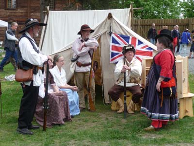
Animation
Fort Langley
23/05/2011

Ford T
Fort Langley, Museum
23/05/2011
Finally the parcel came, it was available at the Main Post Office in the late morning. The spare parts to repair the diesel cooker, some medicines as well as bulletins of the association of the motor homes on the Silk & World Roads –CCRSM– had passed through the customs without difficulty. In the afternoon I looked for a workshop to carry out the replacement of the defective parts of the diesel cooker, to follow.
I left Vancouver without regret after having solved a last problem at my computer, Toughbook CF-19, whose Wireless card was deactivated suddenly. A workshop found a solution by uninstalled the card that Windows reinstalls automatically! I hope it is a good repair. I headed again Hwy 1 then Hwy 97 in opposite direction of the previous week northwards within B.C. then to Yukon –YT– and perhaps to Alaska. I lunched at Yale Tunnel where I had bivouacked on May 21; I noted that summits were always covered with snow. With pleasure I found again a satisfying working of my diesel cooker whose glow plug had been replaced following the reception of spare parts contained in the parcel delivered the day before.
Rest area
Yale Tunnel
25/05/2011
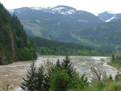
From Lytton Hwy 97 takes the name of Cariboo Hwy and is a historical place –Gold Rush Trail– of which 0 Milestone is at Lillooet. The road skirts the Fraser River in a splendid valley whose each edge is traversed by a railway.

Historic Landmark
Hwy 97
25/05/2011
Weather was rainy, I found a bivouac before Spences Bridge at the foot of the church of the village. Hardly arrived the rain fell down violently.

Church
Spences Bridge
25/05/2011
The Cariboo Wagon Trail
Cariboo Wagon Trail was built by engineers of the British army in the 1860's from Lillooet, 0 Mile Stone, traversing 400 miles, around 644 kilometres. A road house was built every 12 or 14 miles. In the 1800's it was considered the eighth wonder of the world.
The day occurred entirely in the rain; the heavy trucks drove at the authorized speed 100km/h passing me witht a curtain of plugging rain. In spite of splendid landscapes along Fraser River then of Fraser Plateau it was not a real pleasure of touring. On the way little before Hat Creek Ranch I discovered a small river called Bonaparte, very strange for a country formerly managed by the British!

En route
26/05/2011
Hat Creek Ranch is one of the largest still surviving road house of Cariboo Wagon Trail. It is a place very visited by Canadians, several tourist buses were on the carpark. Under the veranda a picture of the Gold Rush era in the 1860's shows wagons harnessed with eight horses.

Old Roadhouse
Hat Creek Ranch
26/05/2011

Wagons
Hat Creek Ranch
26/05/2011
Further away I lunched on the carpark of Chasm Park whose landscape was drowned with fog and copiously sprinkled with rain. Throughout the road remaining road houses were as much milestones, 47 Mile House, 70 Mile House, 100 Mile house for the main ones. I tried to find a bivouac at the edge of the Lake La Hache alas occupied by residences, I were satisfied with a quite wet rest area.

The Chasm
Chasm Park
26/05/2011

The Chasm
Chasm Park
26/05/2011
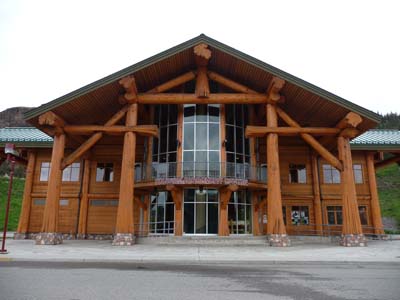
Day without rain but without much of attractions, at Williams Lake a sumptuous log Visitor Centre except the harvest of booklets did not present much interest if not the central sculpture of a tangle of sport items used in the area.
Visitor Centre
Willians Lake
27/05/2011

Visitor Centre
Williams Lake
27/05/2011
Further away in Quesnel a Visitor Center offered a free WiFi connection and the contiguous museum presented the usual odds and ends with an ancient picture and a modern mask.

Museum
Quesnel
27/05/2011

Museum
Quesnel
27/05/2011
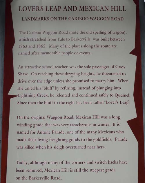
On the move towards Bakerville I found a bivouac on the carpark at Mexican Hill whose poster tells a piece of history.
Bivouac
Mexican Hill
27/05/2011

The road tracklog
from Mexican Hill to Smithers
from 2011/05/28 to 2011/05/29
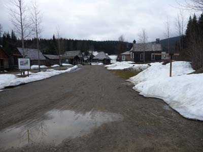
Barkerville
Barkerville was set up in 1862's after William Baker had discovered gold rom which it drew $6 million. In 1865 Cariboo Wagon Road reached Bakerville allowing a regular provisioning of the village. In September 1868 a fire devastated the city which was rebuilt before winter. But soon the dream disappears and the city declined quickly. The current houses were reconstituted from pictures of this time. The site is opened for tourism tabout mid-May after the snow melt, the altitude of the village is around 1300 meters high. The tourist activity was not very big yet. The visit of the site shows the roughness of the life of the gold diggers at this latitude under very difficult conditions.

Old house
Wells
28/05/2011
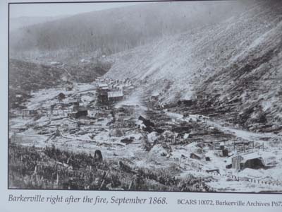
In 1868
Barkerville
28/05/2011
Under snow
Bakerville
28/05/2011
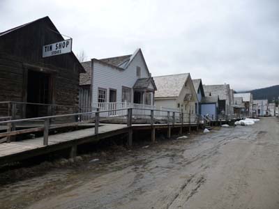
Boardwalk
Barkerville
28/05/2011

Bakerville
28/05/2011

Sunny side
Barkerville
28/05/2011

Dentist
Bakerville
28/05/2011

Chinatown
Barkerville
28/05/2011

Bakerville
28/05/2011
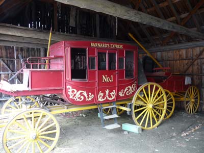
Coach
Barkerville
28/05/2011

Actors
Bakerville
28/05/2011

Church
Barkerville
28/05/2011
The following day was still a sunny day in landscapes of great beauty, mountains covered with conifers, green meadows sown with spring flowers and lakes with dark water. Altitude is around 700 meters high. But the population is never very far. In spite of the north of British Columbia it is impossible to be alone as in Australia. In this last Sunday of May Visitors Centres and museums along Hwy 16 were closed, not what to rinse an eye except in Vanderhoof at the Bank of Canada and at a log house. I bivouacked in Smithers on the way towards Prince Rupert. Distances between bivouacs lengthened.
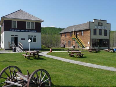
Museum
Vanderhoof
29/05/2011

Teller's Bank of Canada
Vanderhoof
29/05/2011

Log Building
Vanderhoof
29/05/2011
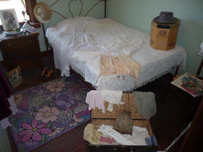
Bedroom
Vanderhoof
29/05/2011

Landscape
En route Hwy 16
29/05/2011