-- From the USA/Canada border to Inuvik & back to the jct between Dempster & Klondike Hwys

The road tracklog
from the border to Inuvik & back to jct
from 2011/07/10 to 2011/07/17
From the USA/Canada border to Dawson City
For the border crossing look at the travelog of USA.
I got of George Black Ferry in the late morning to head towards the Visitor Centre. By getting out of my truck someone came to meet me, Samuel, travelling towards Alaska with his family for a tour of the world. We exchanged information by envisaging to see again later in Dawson. The city was quasi deserted in this Sunday, I understood later, except the two museums all was closed, “Sunday is closed”.

Yukon Territory, Canada
Dawson
10/07/2011
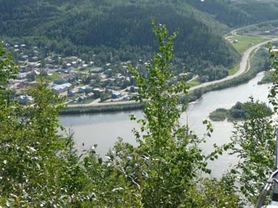
Bird's eye view from the Top of the World Hwy #9
Dawson
10/07/2011
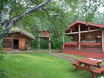
However thus I visited the Jack London Museum recalling the life of the author in Yukon Territory. His cabin and his cache were rebuilt with materials of the original buildings found in the south of Dawson.

Jack London
Dawson
10/07/2011
Jack London's cabin & cache
Dawson
10/07/2011
Then I visited Dawson City Museum housed in the old territorial administration building. It makes a large place to the mining activity in Klondike at the Gold Rush time by showing protagonists and controversies about the gold discovery. On the second floor some display cabinets exhibit items of this time.

Trombinoscope
Dawson
10/07/2011
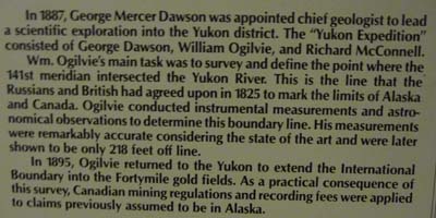
William Ogilvie
Dawson
10/07/2011
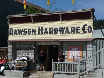
Benefiting from a sunbeam between two downpours I strolled in the city on the gravel streets at discovered old houses, dull city in this Sunday. In the late afternoon I drove up to the Dome to see the midnight sun, look at Gallery-3, and to bivouac on the spot.

Kate's cabaret
Dawson
10/07/2011
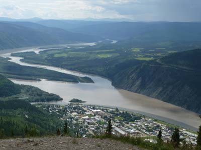
Bird's eye view from the Dome
Dawson
10/07/2011
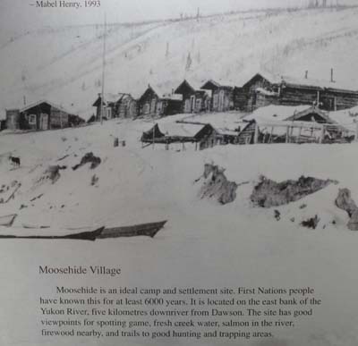
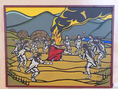
I headed down from the Dome around 10am to visit two sights in Dawson, Dänojà Zho Cultural Centre and the SS Keno, not what to be happy. The Cultural Centre dedicated to the people of the river -Tr'ondëk Hwëch'in- exhibits in two rooms of artifacts and pictures of these people which lived since the night of times at the edge of Yukon River and of Klondike River with hunting territories in mountains.
Dänojà Zho Cultural Centre
Dawson
11/07/2011
Dänojà Zho Cultural Centre
Dawson
11/07/2011
Then I strolled in the city looking for some scoops, nothing, some patched up or not houses. About midday I went to the library to publish the pages of my website and to read the French newspapers, nothing with enthusiasm, politicking rumours and sinks financial future in Europe…
Village
Dawson
11/07/2011

Village
Dawson
11/07/2011
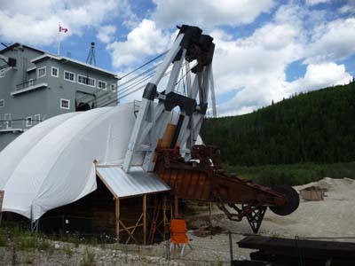
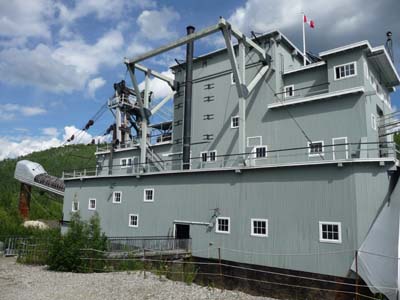
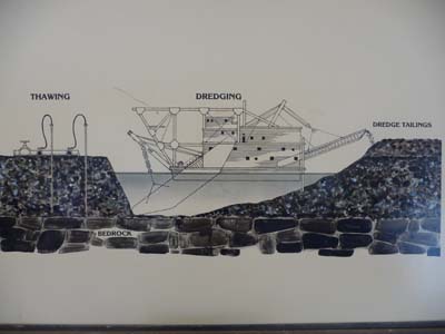
In the early afternoon I drove to Bonanza Creek to see an enormous Dredger #4 at 3000 tons weight and 8 stages high. Built in 1912 it was operational until 1940. It extracted 800 ounces of gold per day from April to November in three shifts of four men, big business! The diagram shows the production process.
Drague #4
Dawson
11/07/2011
Drague #4
Dawson
11/07/2011

Dredge #4
Dawson
11/07/2011
Dredge #4
Dawson
11/07/2011
In the evening I was scoundrel myself in Diamond Tooth Gerties the Canada's oldest casino with a can can dance performance of good behavior.

Diamond Tooth Gerties
Dawson
11/07/2011
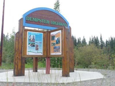
Dempster Highway #8
In 1958 the Canadian government made the decision to build a road from Dawson, Yukon Territory, to Inuvik, Northwest Territories, the exploitation of the oil-bearing fields in Mackenzie Delta was booming. It was built as from January 1959 and was opened on August 18, 1979. At the Visitor Centre in Dawson I received a Dempster Hwy Passport to make it stamped at certain point as proof of my passage, of course nothing official, a game.
Dempster Hwy
12/07/2011

Dempster Hwy
12/07/2011
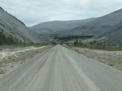
After Dawson on Hwy # 2 at kilometre 40 I forked towards Dempster Hwy # 8 to head to Inuvik in two days on gravel road of bad reputation. En route I stopped at some points of interest mentioned on the map. The first was at Tombstone Interpretive Centre where a rangers made me a moose watched with the long sight. I retained two pictures, that of Ogilvie who fixed, in particular, the border between Alaska and Canada and that of two cyclists on the Hwy in winter, what a courage! On the road traffic was very sparse, the temperature was lenient with sometimes a grain of rain.
Dempster Hwy #8
en route
12/07/2011

Tombstone Interpretive Centre, 72 km
Dempster Hwy #8
12/07/2011

Tombstone Interpretive Centre
Dempster Hwy #8
12/07/2011

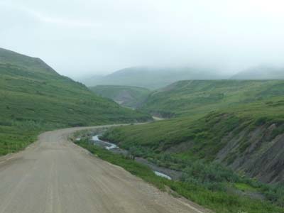
The gravel Road
Dempster Hwy #8
12/07/2011
The day started with an execrable weather, rain and fog up to 80 km before Inuvik that is to say for about 350 km of a gravel road.

At 7am
Dempster Hwy #8
13/07/2011
In Yukon I crossed for the second time in North America the Artic Circle but in the rain and surrounded by a cloud of very virulent mosquitoes which drank my blood to satiety, lasts to take a picture.
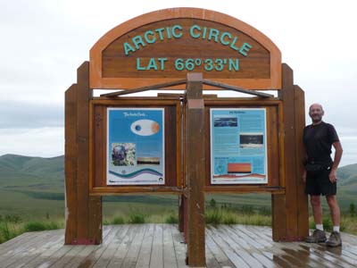
Artic Circle, Yukon
Dempster Hwy #8
13/07/2011
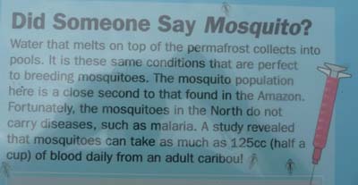
Mosquito?
Dempster Hwy #8
13/07/2011
Then I entered the Northwest Territories, landscape changed, for what I saw, the road twisted between the Richardson mountains.

Border between Yukon Territory & Northwest Territories
Dempster Hwy #8
13/07/2011
NWT landscape
Dempster Hwy #8
13/07/2011
Finally the good weather came, I entered Inuvik in the sun. On MacKenzie Rd I warned the agency Up North Tours where I booked for the following day, July 14 day of our national festival, a tour to visit Tuktoyaktuk with a flight and a return in boat for a duration of about eight hours. Before looking for a bivouac I paid thanks to the Inuvik's icon Our Lady of the Victory Church in the shape of igloo.
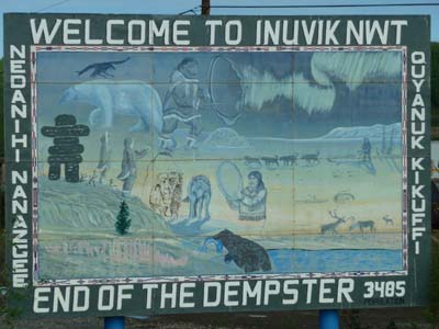
Inuvik
13/07/2011
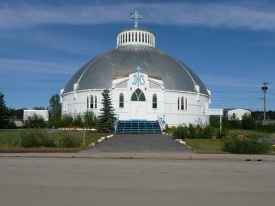
Our Lady of Victory Church
Inuvik
13/07/2011
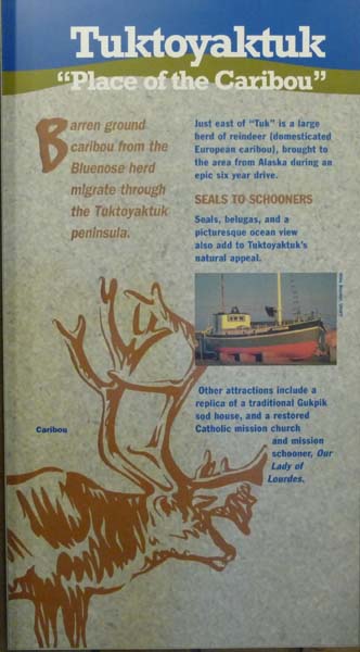
Tuktoyaktuk
The day of July 14 was long and enthralling. The Flight, about 45 minutes, made it possible to see not only Inuvik and Tuktoyaktuk but also the Mackenzie Delta one of the largest in the world. The GPS red tracklog, look above, of the flight is in two straight lines of which the first one is hidden by the end of the tracklog of the boat in MacKensie Delta.
Bird's eye view
Inuvik
14/07/2011
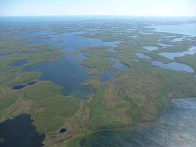
Bird's eye view
MacKenzie Delta
14/07/2011

Pingo
MacKenzie Delta
14/07/2011

Pingo
14/07/2011
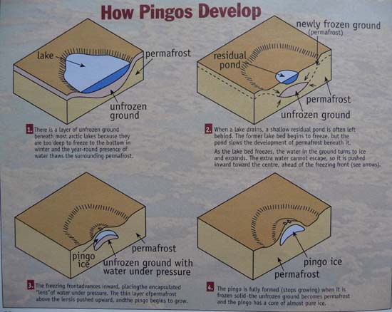
Pingo
14/07/2011
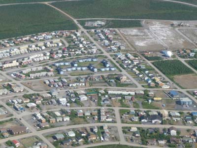
We were accommodated at the landing by a local guide to visit the village for two hours. It is built on a strip of land at the edge of the Beaufort Sea with houses on pile to reach the non frozen ground. The activity is centered on art & craft, fishing & hunting, for food during winter, as well as governmental employment.
Tuktoyaktuk
14/07/2011

Bird's eye view
Tuktoyaktuk
14/07/2011
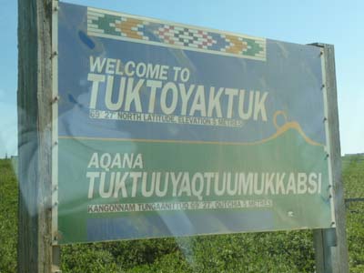
Tuktoyaktuk
14/07/2011

Bird's eye view
Tuktoyaktuk
14/07/2011
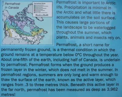
Underground galleries in permafrost are used as community fridge to store food.

Community fridge
Tuktoyaktuk
14/07/2011
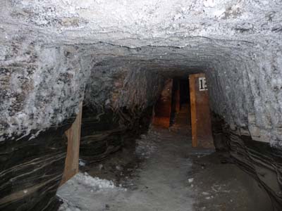
Community fridge
Tuktoyaktuk
14/07/2011
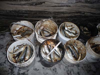
Community fridge
Tuktoyaktuk
14/07/2011
A traditional house, out of wood covered with ground, is used for meetings during the long night days in winter.
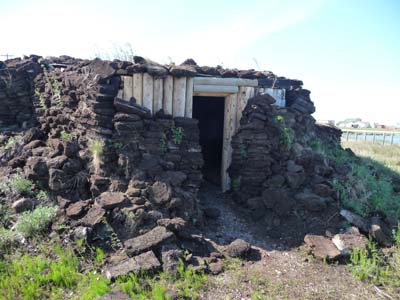
Traditional house
Tuktoyaktuk
14/07/2011
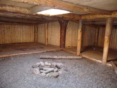
Traditional house
Tuktoyaktuk
14/07/2011
On the way back by boat, about seven hours, we made several stops of which one to visit the settlement of a family of fisherman with preparation of salmon for drying.

Fisherman settlement
MacKenzie Delta
14/07/2011
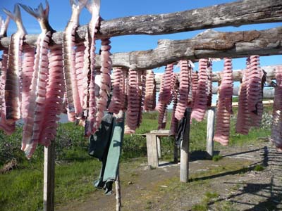
Salmon drying
MacKenzie Delta
14/07/2011

Fish preparing
MacKenzie Delta
14/07/2011

Girl
MacKenzie Delta
14/07/2011
Back to the Klondike Highway
The morning was occupied in administrative work and at the library for Internet. I left Inuvik after lunching by Dempster Hwy in the other direction. Weather was partially sunny with clouds scattered announcing a bad weather. The track up to the ferries over Mackenzie River then Peel River was in good condition and traffic was fluid in this Friday. Towards the border of Nordwest Territories and Yukon Territory a violent wind circulated between the mountains, I bivouacked at the border by changing time, back one hour.

Little flower...
Dempster Hwy
15/07/2011

Already seen on the outward journey in the other direction
Dempster Hwy
15/07/2011
The second driving day started in the rain up to the approximately km 200 where the sun was shown timidly behind the clouds. I saw only some small animals fleeing in front of my truck, hares, squirrels and perhaps a grouse of the willows close to Blackstone. Of course in edge of the track red, pink and white flowers,.

Little flower...
Dempster Hwy
16/07/2011
Already seen on the outward journey in the other direction
Dempster Hwy
15/07/2011
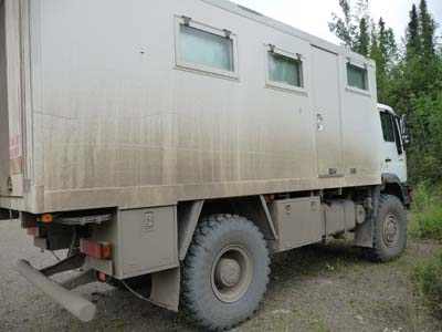
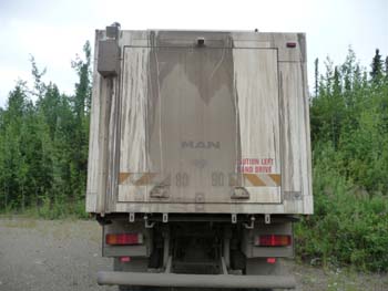
Sunday broke up into two parties, the first to join the intersection between Dempster Hwy and Klondike Hwy where is Klondike River Lodge, petrol station and campground. The second was to wash my truck during two long hours then to take a shower. Finally around 5 p.m. I put at administrative work, preparation of the publication of the pages of my website.
Final report to Tuktoyaktuk
1---- Dempster Hwy does not correspond to its bad reputation, 80% of the
track is good, all is relative, and 20% are bad, holes and corrugated sheet.
2---- There are little traffic some heavy trucks and private cars. I
met some motor homes and some motor bikes. Weather was rainy during the
mountainous trip from the km 82 to the km 650.
3---- Landscapes resemble those of Dalton Hwy in Alaska, therefore
nothing new. The crossing of Artic Circle is of course the same as in
Alaska. This journey is justified primarily by the excursion to Tuktoyaktuk.
4---- I obviously hated the degraded parts of the track. The distance covered
was 1540 kilometers return Klondike & Dempster Hwy Jct.