-- From Pakse to Pakse, Phou Asa, Si Phan Don, Wat Phu
The road tracklog
From Pakse to Pakse
From 26/12 to 01/01/2009
The 26/12 I left for the village Kiet Ngong where I wished to arrange a trek to Ta Ong. Alas it was not possible. I headed again to Pakse to arrange it with Tourism Office; new disappointment, it was there impossible too. I spent the remainder of the day in Pakse, where I point out it does not have nothing to look at.
However thus 27/12 I took again the road southwards to fork again at Ban Thang Beng to go to Kiet Ngong where I stopped to visit Phou Asa.
At the top of a hill overhanging the wetland in the south of the Bolaven Plateau and in the west of the Annamite Range, a strange structure made up of columns of two meters high out of dry stones capped with a broad flat stone surrounds a perimeter of 180 meters by 50 meters with in the centre a crumbling building which would have been a temple. Legends abound on this structure dating back to thousand years at the maximum. Its name comes from a group of nationalists who fought the Siamese victoriously in the 19th century.
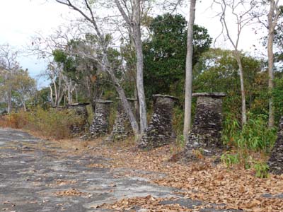
Alignment of columns
Phou Asa
27/12/2008
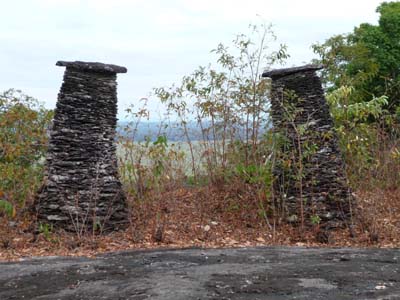
Columns
Phou Asa
27/12/2008
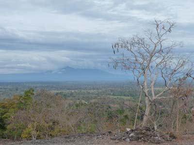
Bird's eye view
Phou Asa
27/12/2008
The village of Kiet Ngong is inhabited mainly by Lao Loum farming rice and breeding elephants for forest work as well as tourism. It is located within Xe Pian National Protected Area.
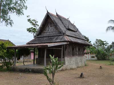
Buddhist Temple
Kiet Ngong
27/12/2008
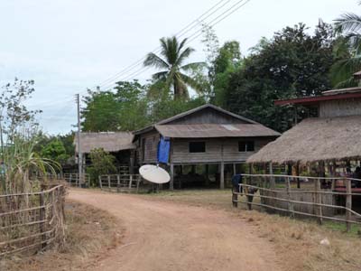
Main street
Kiet Ngong
27/12/2008
Whereas I read some pages of my bedside book before going to bed, two villagers called me by saying “Police”. They made me understand with the sign to cut the throat that I was to follow them. I obeyed and I put my truck in the courtyard of a house opposite the school entry.
The 28/12 I continued to progress southwards to stop close to the border of Cambodia.
Si Phan Don
The breathtaking four thousand islands are located on Mekong at the border of
Cambodia. By going up Mekong, the most visited islands are Don Det & Don Khon
then the largest Don Khong. Two waterfalls are well known:
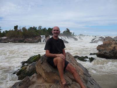
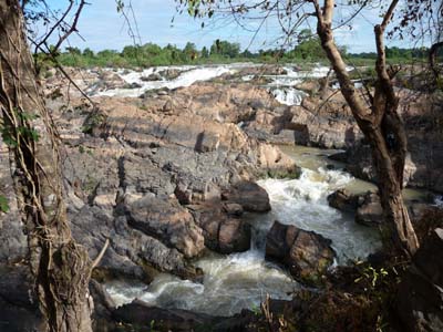
---- Khone Pha Pheng Waterfall the southernmost and the largest in all the
Southeast Asia.
---- Som Pha MIT (Li Phi) Waterfall located on the island of Don Lai.
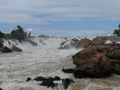
Khone Phan Pheng Waterfall
28/12/2008
Portrait
Khone Pha Pheng Waterfall
28/12/2008
Then I drove northwards to fork to Ban Nakasang, the pier for Don Det & Don Khon. The three kilometres of laterite road were bumpy. The village was noisy and dusty; I established there my bivouac on the official carpark.
The 29/12 I negotiated a boat to go to Don Det where by Sunrise blvd then by the unused rail bed I reached the railway bridge connecting Don Det to Don Khon. Not far I admired the rusting locomotive which worked until WWII.
The unfinished
The French colonial administration had planed to make a commercial highway from Saigon to Yunnan, China, of navigable Mekong River. It was necessary to bypass falls and rapids on Mekong River; for that a narrow gauge railway was built on the islands of Dont Khon & Don Det. It functioned up to the WWII. Alas Mekong never became the hoped trading route and the railway remained single in Laos.
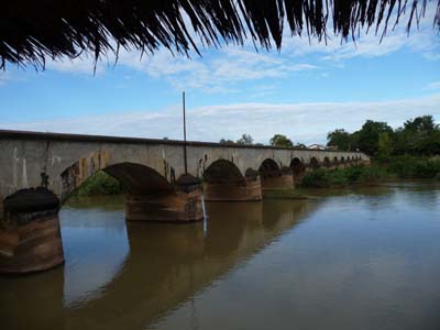
Pont ferroviaire
Don Det & Don Khon
29/12/2008
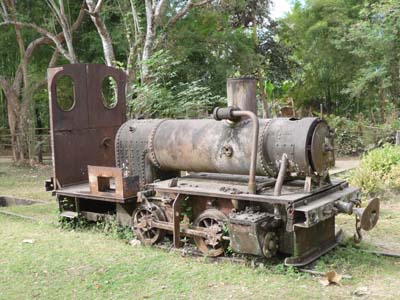
Locomotive rouillée
Don Khon
29/12/2008
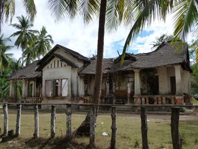
Bâtiment colonial
Don Khon
29/12/2008
Then I crossed the enclosure of Wat Khon Tai to take a track leading to Don Lai n to look at Tat Som Pha Mit (Li Phi) Waterfall where Mekong River force multiple ways through rocks. I continued my strolling towards the pretty beach of Kong Ngay where I took rest before continuing my walk southwards of Don Khon. At the village Ban Hang Khon I rented a boat with the hope, disappointed, to look at Irrawaddy Dolphins of which I had seen the caudal fin in Kratie, Cambodia. Alas after one hour of waiting I did not see anything!
Som Pha Mit Waterfall
Don Lai
29/12/2008
After having lunch I took again my walk northwards to return by boat from Don Det to Ban Nagasang where my truck was. This pedestrian day was enriching by the colonial ruins, the Laotian’s rural life and the wild beauty of the Mekong River’s falls. The following stage being the visit of Wat Phu Champasak I always moved northwards and I stopped on the move to bivouac on the surface on a Weigh station area.
The 30/12 I went to Lak 30 on the main road 13 to fork towards the Mekong River where I
took a ferryboat from Ban Muang to Champasak. The ferry consisted of three
metal barges assemblies by beams. Confidence should be made.
In the afternoon I visited the city, a single street along the Mekong River,
where few curiosities were houses of the colonial period and residences of
kings of Champasak. Then I establish the bivouac not far from Wat Phu.
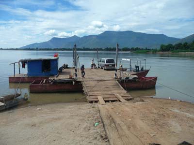
Ferryboat
Ban Muang
30/12/2008
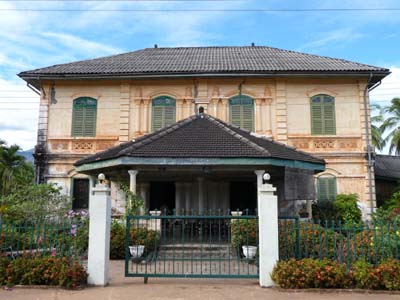
Résidence Royale
Champasak
30/12/2008
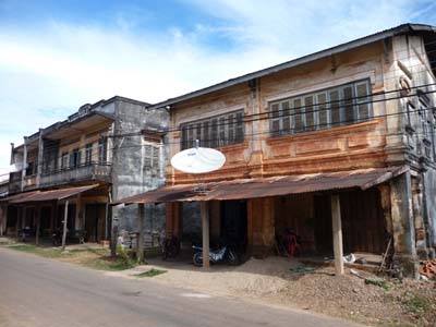
Maisons coloniales
Champasak
30/12/2008
Wat Phu
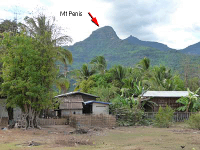
At the foot of the Phu Pasak mountain, colloquially called Phu Kao or Mt Penis,
manifestation of Shiva, god of the fertility, on an axis from west to east up
to Mekong River were built the complex of Wat Phu and the ancient city of
Kuruksetra, capital of a Chenla kingdom in 5th century.
At the beginning Wat Phu was dedicated to Shiva; its architecture is pre-Angkorian and late Angkorian
style. It was the representation of the vision of
the universe and the heaven according to former Khmers'.
A sacred sprint at the foot of cliff gave water to bath the lingam, this lustral water
was then led into the barays and it fertilized the surrounding fields.
It was then converted
to Buddhism. The main temple was built on the slope of the sacred mountain
with some buildings along the processional causeway leading to a Baray, reservoir
for worshipper’s ablutions.
The site of Wat Phu was registered with the World Heritage in 2001.
Phu Pasak
Wat Phu
30/12/2008
The 31/12 I began the visit of Wat Phu as of the opening hoping to look at sunrise on the
site, alas the sky was covered for several days. The site is breathtaking
streching on more than one kilometre from the foot of the mountain. Some
buildings were under restoration. I strolled agreeably by discovered of
interesting ruins. The small didactic museum exhibits rare English labelling
parts.
I went back there after having lunch. Since the sanctuary I contemplated the
site in his landscape with a wide-angle view to Mekong River. It returned to
me then in memory a thought of Nicolas BOUVIER published in his Japanese
chronicles: “The way in which a people looks at its origin tell some more than
scientific studies” (it is the mind and not the letter).
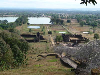
Wide-angle view
Wat Phu
31/12/2008

Sanctuary
Wat Phu
31/12/2008
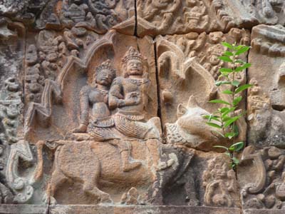
Shiva & Parvati sitting on Nandi
Wat Phu
31/12/2008
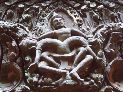
Vishnu killing his uncle
Wat Phu
31/12/2008
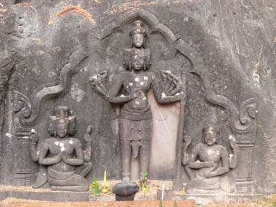
Trimurti: Shiva, Vishnu & Brahma
Wat Phu
31/12/2008
The 01/01/09 I took again a ferryboat in Champasak to head back to Pakse where I went to Tourism Office to try and organize the trek to Ta Ong. This first day of the New Year 2009 was a happy day. The trek took place with three participants yet. Thus the following day I left in trek for two days.