-- From Phonsavan to Luang Prabang
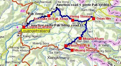
The road tracklog
From Phonsavan to Luang Prabang
From 01/02 to 08/02/2009
Sunday February 1 I have the surprised visit of two girls in costume of the Hmong ethnic group. It was a meeting of photographs at the foot of Lao War Memorial where I had bivouacked. The day was announced beautiful in spite of a fog covering the plateau.
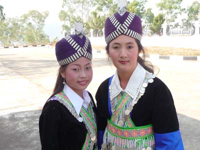
Ethnie Hmong
Phonsavan
01/02/2009

Ethnie Hmong
Phonsavan
01/02/2009
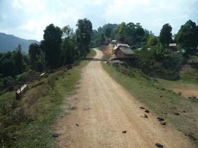
Alas heading northwards to reach Muang Kham I drove a mountain road in fog. I had hoped to see other Hmong in Nong Pet, but it was not the market day. I continued up to Muang Kham target of this day where I was able to lunch close to the crossroads 7 and 6. I bivouacked on the spot.
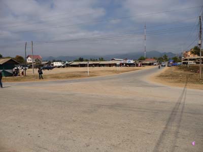
Carrefour 7-6
Muang Kham
01/02/2009
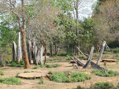
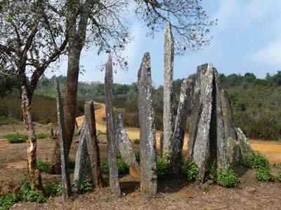
The 02/02 was a long driving morning to go to Hintang Archeological Park on road 6 towards Sam Neua. The road meandered in mountains at 1500 meters GPS between cliff and ravine in morning fog crossing through infant crammed thin villages, no family planning! The junction between road 6 and road 1 towards the west is not in Nam Noen but in Phou Lao. Heading eastwards I found a track to the park in Ban Phao, it is out of laterite and rather steep. I arrived at the park around 12:00 where an abandoned house and an explanatory panel announced it. The archaeological monuments are at the edge of the track without protection, some children played hide-and-seek between the menhirs, new album of Astérix. As the panel mentions it the site was studied in 1931 by Madeleine Colani. It is sometimes, excessively, likened to Stonehenge in England. I bivouacked two nights on the spot.

Suan Hin
Hintang Archeological Park
02/02/2009
Menhirs
Hintang Archeological Park
03/02/2009
Menhirs
Hintang Archeological Park
02/02/2009
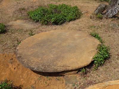
Disque
Hintang Archeological Park
02/02/2009
After a rest day the 04/02 I was again early on the road expected to a dirt track from Phou Lao to Vieng Thong. It was not the case; the road was sealed but narrow. I was able to have lunch in Vieng Thong where I established a bivouac at the east entry city. The office of Phu Loei NPA had neither map nor booklet and Hot Spring was very small. On the move I have the surprise to see fields of horticulture with a small temple dedicated to the local "Phi" as well as cultivated rice paddies.
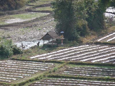
Horticulture and "Phi" temple
en route
04/02/2009

Cultivated rice paddies
en route
04/02/2009
The 05/01 was still a driving day on road n°1. I did not meet any vehicle in the two
directions; only motorcyclists circulated, I noticed that some carried a
weapon likened to a Kalashnikov.
I had bought a booklet of the Luang Prabang Province at Tourism Office in
Vientiane. One of the maps mentioned a track starting from the road n°1 before the
village of Sam Soun towards Luang Prabang via Pak Xeng. The Russian map of
Touratech did not indicate it, but I can trace it roughly. The landscape would
be undoubtedly of great beauty.
Indeed little before Sam Soun on the left a laterite track was very marked. It
strolled from croups to hollows along watersheds crossing through small passes.
Landscapes of
medium mountains, 1250 meters GPS maximum, were dramatic as well as villages
crossed with many children acclaiming me with "Sabaï Dee".
I bivouacked at the edge of the track on the move towards Pak Xeng.
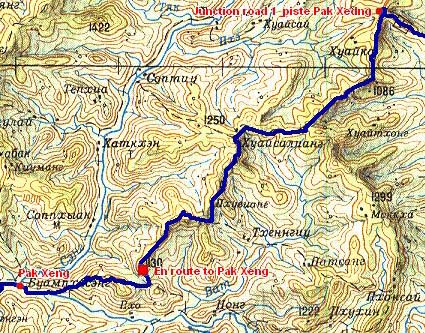
The road tracklog
from junction road 1to Pak Xeng
from 05/02 to 06/02/2009
a dirt track
en route
05/02/2009

Flowered
Village fleuri
en route
05/02/2009
06/01 I was again on the track towards Pak Xeng where I arrived around 09:00 which became
wider and well surfaced up to the junction with road 13 towards Luang Prabang.
The section of the track between road 1 and Pak Xeng is highly worthy for
landscapes and crossed villages, it would be judicious to envisage several
days to be delayed there. The track is not gullied by rain water; it would be
practicable during the wet season, to check before leaving.
I had lunch in a student restaurant vis-à-vis the LP University entry. In
early afternoon I found a bivouac in the Souvannakhamphong Road between the
Mekong River and the Wat Xieng Thong. In the late of the day I took height by
climbing the few 300 steps to the Phu Si Mount to see the sunset on the city.

Landscape
en route
06/02/2009
Luang Prabang
The city is located on a peninsula at the confluence of Mekong River and Khan River
surrounded by mountains at an altitude of approximately 700 meters. As of the
8th century it was the capital of a City-state of Thai-Lao under the name of Muang Sawa.
In 1353 King Fa Ngum created the first Lao kingdom, Lan Xang Hom
Khao, it gave the name of Dong Xiang Thong to the city. In 1512 King Visoun
accepted the Buddha Pha Ban as present from the Khmer Empire, it changed the
name of the city into Luang Prabang. In 1867 French arrived at Luang Prabang,
in 1887 France established the protectorate of Lao. The city became the refuge
of the French colonials far away from Paris.
The charm of Luang Prabang lies as well in its localization as in legacy of
its remote and close past.
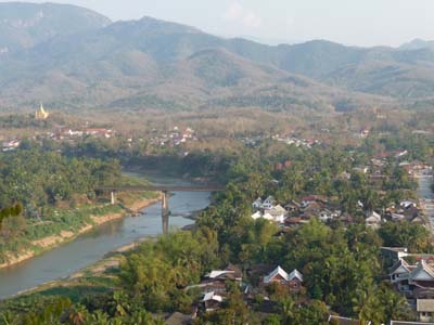
Panorama
Luang Prabang
06/02/2009

Le vieux quartier français
Luang Prabang
06/02/2009
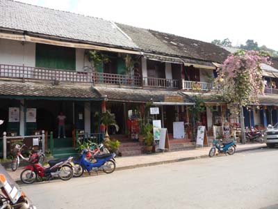
Le vieux quartier français
Luang Prabang
06/02/2009
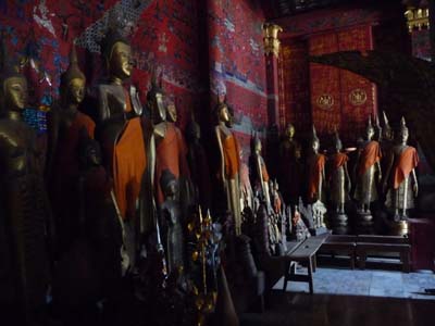
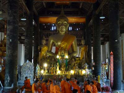
The 07/01 was long and beautiful sunny walking day by discovering Luang Prabang while following the circuit proposed by the Lp. The city counts more than 32 temples; I visited the major monuments while strolling in the lanes of the Old French quarters whose restored houses became guesthouses and restaurants. It is not possible to publish the few 80 photographs; I selected seven representative of local architecture:
The veranda of Wat May Suvannaphumaham whose gilded sculptures tell the legend of Vessantara.
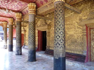
Wat Mai Suwannaphumaham
Luang Prabang
07/02/2009
The characteristic architecture of Lang Prabang, picture in cover, of Wat Xieng Thong as well as the coloured glass mosaic representing the “tree of life” nearby to the red chapel of the reclining Buddha who was exposed in Paris in 1931.
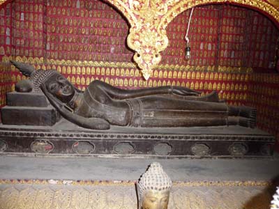
Wat Xieng Thong
Reclining Buddha
Luang Prabang
07/02/2009
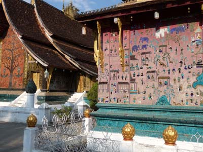
Wat Xieng Thong
Luang Prabang
07/02/2009
Wat Xieng Thong
Funerary Carriage House
Luang Prabang
07/02/2009
The oldest temple of the city Wat Visunarat where I attended the ordination of two young monks whose trousseau was exposed to ask for gifts of tourists.
Wat Wisunarat
Luang Prabang
07/02/2009

Wat Wisunarat
Ordination de moines
Luang Prabang
07/02/2009
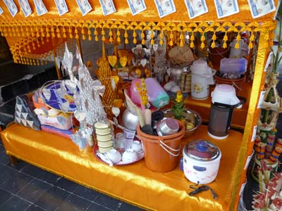
Wat Wisunarat
Monk's trousseau
Luang Prabang
07/02/2009
The following day was devoted to the preparation of the publication of the pages of my website and to a long strolling in the city. I met two French young people, Ben and Sev who build a campervan on an Iveco chassis. We exchanged information.