-- From Fairbanks to the border on the Boundary Spur Road

The road tracklog
from Fairbanks to the border
from 2011/07/04 to 2011/0710
Independence Day
Monday July 4 is the Independence Day of the United States of America whose festivities proceeded in Pioneer Park in particular from the galleries of S.S. Nenana, steamer which sailed on Yukon River. I went initially to Cultural & Visitors Center for the usual collection of booklets and the stroll of the Exhibition Hall: The People and the Land.

Visitors Center
Fairbanks
04/07/2011
Hat
Fairbanks
04/07/2011
Before noon I was in Pioneer Park to attend the speeches and the concert of US Army Alaska Artic Warrior Band. At the national anthem played by the band all assistants started singing it with the hand on the heart. The park gathers log cabins and a cabaret of the Gold Rush time. I lunched of a hot dog and an apple pie, genuine American.

Pioneer Park, 4th of July Celebration
Fairbanks
04/07/2011

Pioneer Park, 4th of July Celebration
Fairbanks
04/07/2011

Pioneer Park, Gold Rush Town
Fairbanks
04/07/2011
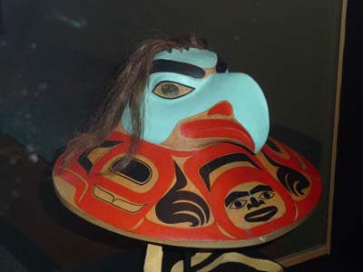
Pioneer Park, Museum
Fairbanks
04/07/2011
I ended the day in University Museum which claims to compete with that in Anchorage, que nenni, except the architecture of the building.
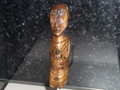
University Museum, Madonna
Fairbanks
04/07/2011

University Museum, Logic Board
Fairbanks
04/07/2011
The next day as of 8:00 am I was at Pioneer Glass to have the two gravel impacts on the windshield repaired. Then I washed my truck of the Dalton Hwy mud, the operation lasted more than one hour and a half.

Pioneer Glass
Fairbanks
05/07/2011
I was at 11 a.m. at the opening of the Antique Car Museum which exhibits vehicles built by the USA. Although not being regarded as a pioneer of automobile creation the vehicles presented show their adequacy with the American way of life, splendid Packard, Auburn and Cord without forgetting the very versatile Ford “T”. It was a great moment of the story of the car makers in the USA with trademarks now disappeared.

Antique Car Museum, Ford "T" Snow Flyer
Fairbanks
04/07/2011
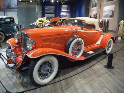
Auburn 1933
Fairbanks
05/07/2011

Dresses "1930"
Fairbanks
04/07/2011
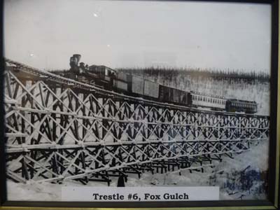
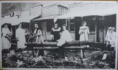
I benefited from this sunny day to stroll the small downtown along the Chena River where I discovered the remarkable stained glasses of St Matthew's Episcopal Church. I spent a long moment within Fairbanks Community Museum which shows interesting pictures of the Gold Rush's era, Fairbanks was on the trail of the gold diggers from Valdez to Dawson City, access to Klondike Area. It was one day rich of the recent history of Alaska. I bivouacked at Riverview RV at Badger.

Golden Heart Plaza
Fairbanks
05/07/2011

Fairbanks Community Museum
Fairbanks
04/07/2011
Dawson City
Fairbanks
05/07/2011
St Matthew's Episcopal Church
Fairbanks
04/07/2011
The WiFi Internet connection at Riverview RV was good but their contract with the provider had a slow connection from where quasi an impossibility for consulting the French news papers. Consequently I returned to Fairbanks stationing at Walmart and going to McDonald's for Internet. I went shopping and rested me. The weather was beautiful with a high temperature in Alaska.
I left Fairbanks by Alaska Hwy # 2, on the move I did three visits. Initially a small detour to glance at the village where Santa Claus lives, North Pole which is not at the North Pole. It receipt one of the two poles released out of a plane to the North Pole then to recover and installed here.

The North Pole
North Pole
07/07/2011

The North Pole
North Pole
07/07/2011
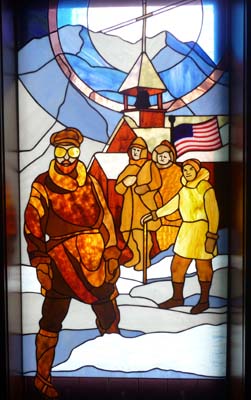
Then I stopped at greater length in Rika's Roadhouse which played an important part during the Gold Rush. The site is a park where it is pleasant to stroll among the vestiges of the past. There are many buildings, barns, a telegraphic station and others. Interpretive signs explain the real life at that time with pictures, very instructive to understand the tenacity of men at this era.
Interpretive signe
Rika's Roadhouse
07/07/2011
The Roadhouse
Rika's Roadhouse
07/07/2011

Interpretive sign
Rika's Roadhouse
07/07/2011
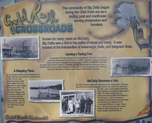
Shortly after it was Delta Junction except the Mile Post of the official terminus of Alaska Hwy it does not have nothing there.

Visitor Center
Delta Junction
07/07/2011

Visitor Center
Delta Junction
07/07/2011
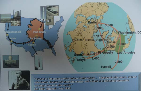
But on the first floor of Visitor Center I discovered an interesting picture showing the strategic interest of Alaska which involved the recent construction of Fort Greely where missiles are stored.
Visitor Center
Delta Junction
07/07/2011
Shortly after my bivouac I stopped to admire the rustic community chapel of Dot Lake with inside a naive tapestry of “Cène”.

Community Chapel
Dot Lake
08/07/2011
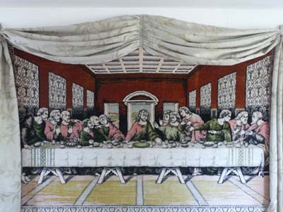
La Cène
Dot Lake
07/07/2011
Taylor Hwy #9
To head to Dawson City in Yukon, Canada, I decided to take the Taylor Hwy # 9 which becomes a gravel road of bad reputation starting from Chicken, if not it is necessary to continue southwards on Alaska Hwy # 2 up to Whitehorse, Yukon, Canada, then northwards by Klondike Hwy # 2 up to Dawson, it is a long detour.

Landscape
Taylor Hwy #9
08/07/2011
Chicken was a mining village well before the Gold Rush in the Klondike area, its population was at the maximum of 400 hearts. Now it is around fifty people in summer and six in winter! Actually it is not any more a village but a whole of shops and camp-grounds to attract tourist, the camp-site-driver, traveler of modern times with a vessel any comfort requiring an electric power connection at 50A. This initiative is due to the very advised businesswoman, Susan Wiren. By climbing Taylor Hwy weather was degraded I ended in the rain and in the clouds. As much to say that by getting out of my truck I waded in the sludge. I made the tour of the shops then I heated me with an American coffee by consulting my mailbox at the a speed. I left this spot without much interest to bivouac on the gravel road.

Tourist trap
Chicken
07/07/2011

!
Chicken
08/07/2011

Cowden Dredge (a steam-driven dredge)
Chicken
07/07/2011

Tourist trap
Chicken
08/07/2011

Tourist trap
Chicken
07/07/2011
Taylor Hwy #9
Eagle
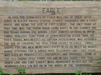
In Jack Wade Junction I continued on Taylor Hwy # 9 up to Eagle the old mining city on mighty Yukon River. Moses Mercier establishes Belle Isle as ctrading posts on Yukon River in 1880. Gold was discovered in Fortymile River in 1886, at Circle in 1893 and at Klondike close to Dawson in 1896. The strategic position of Eagle made it the center of transport, trade and communication for Yukon Territory in Canada and the interior Alaska. The city was created officially in 1897. In 1898 the population was 1700 people living in more than 500 cabins and tents. Today it is not completely a ghost town, but a charming village as there are some in all the countries in the world with vestiges of the past restored or not. Moreover the grassy track for two or three planes of the community shows the intense economic activity.

Road condition
Taylor Hwy #9
09/07/2011
Entrance
Eagle
07/07/2011

Community Well & Wickersham Courthouse
Eagle
09/07/2011

Yukon River
Eagle
07/07/2011

Steamboat Susie at Eagle in 1904
Eagle
09/07/2011
Fort Egbert had its heyday at the time of the border conflict between Canada and Alaska at the time of the Gold Rush then it was a place of maintenance of the telegraph line –WAMCATS– I returned towards Jack Wade Jct to bivouac close to the border of USA-Canada.
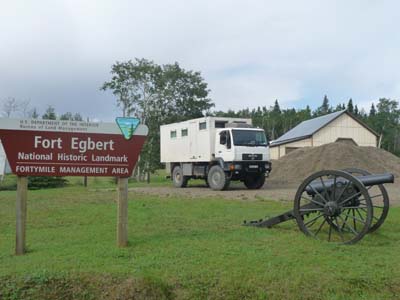
Fort Egbert
Eagle
07/07/2011

Fort Egbert
Eagle
09/07/2011

The NCO quarters
Eagle
07/07/2011
Peopling the Americas

Beringia
09/07/2011
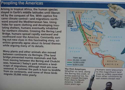
Peopling the Americas
07/07/2011
I left my last bivouac in Alaska around 7:30 am Alaska Time to be at the opening of the border at 9 am Pacific Time, because there is no control at the USA post but ten meters further away at the Canada post. The customs officer spoke French, a true happiness, moreover he was of a remarkable kindness, far from the arrogance of the US customs officers. After the usual questions of which he was excused he granted me a six month visa to my request, duration ten minutes. The "Top of the World Highway" meander on the croups of the rolling mountains at an altitude ranging between 1000 and 1100 meters in green landscapes of great beauty. A long descent of 14 kilometers leads to George Black Ferry to cross Yukon River opposite Dawson City. In Canada I found again the metric system with satisfaction…
Brief final report
I adored the wilderness of Alaska. It is the kingdom of the fresh-water & sea-water fishing, it was regrettable that I would not be fishing. Assigned time did not enable me to stay in the favorable spot for watching animal wildlife; the summer season is very short, it was impossible to visit Alaska and the north of Canada so much the distances are large. It is one of the limits of the journey by motor home, in another life I will travel by faster means of transport.