|
|
 |
Pakistan,
Hindukush |
|
The journey to Hindukush was a 15-day trek for one 29-day stay. The trek was in three parts.
The first part went up the Yarkhun valley, then descended the Karambar
valley, and the Chapursan valley. It was preceded by a tourist part and
ended by the Karakoram Highway on the back to Islamabad.
It was made in 1997,
from August 03 to August 31. After a PIA flight, the arrival in Islamabad
was on time.
The report is in five tables. The general comments are given by the
Pakistan presentation |
|
|
|
|
Tourism |
|
|
|
 |
|
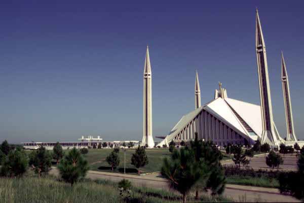
Mosque of Islamabad |
 |
|
A bus in Peshawar |
 |
|
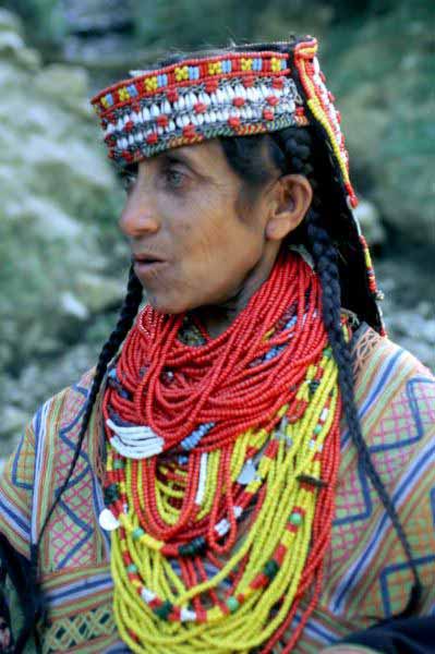
Kafir Kalash |
|
|
Approach: The approach time from Paris to the trek
starting base, Sholkot, was seven days. From Islamabad, the 10-people
group settled with the luggage in a private bus to go in Peshawar, then
two minibuses for Chitral and of the jeeps to Sholkot. The way from Islamabad
to Peshawar took "Grand Trunk Road", a modern road from east to west,
with four lanes, built on the old caravan trail of the Moslem invaders which connected
Kabul to Delhi. The road to Chitral was asphalted then a dirt road.
Islamabad is one of the new capitals built back in 1961 in quadrilateral
shape with perpendicular streets and unattractive concrete buildings.
The Shakarparian park at the Himalayas foothill offers two sites, the
concrete mosque in the shape of Bedouin tent and a viewpoint on the city.
Peshawar is the capital of the NWFP area, English initials "North-West
Frontier Province". The name of the city means, Border Town,
given by emperor Akbar. The group was not authorized to go in
Khyber Pass nor to Tribal Areas. The city is difficult to
know, due to its remote origins and its tormented
present. It was one of the capitals of the powerful Kushan kingdom
after the domination of the Bactrian Greeks, Gandhara.
The museum recalls this glorious past. The bazaar and the mosque are
interesting.
Chitral is a tourist stop to visit the Kalash valleys. The
visit of the bazaar and the mosque is rather interesting. Foreigners
must register at the police station, "Chitral Scouts
Posts" before trekking in the NWFP.
Kalash valleys: This territory is populated of Kafir Kalash,
Kafir=pagan and Kalash=black the colour of women's dresses. They
live in three valleys, Birir, Bumburet and Rambur.
The kalash people are a tourist curiosity in process of Islamization. |
|
|
|
|
|
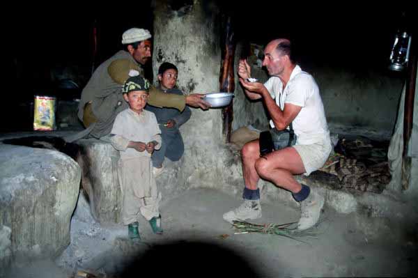
The journey to reach the starting trek base, Sholkot, took one
day and a half of jeep on a dirt road. It is exhausting enough in
torrid heat and dry air. Since our arrival in Pakistan, meeting women
have been extremely rare, the country is Moslem.
Signs mention building financing by the Aga Khan Foundation, AKF,
Ismaili Shia.
|
|
|
|
|
The Yarkhun
valley |
|
|
|
|
Yarkhun:
The Yarkhun river takes its source at the foot of the Broghil
pass, 3,600 m high. It runs is from east to west to bend to the south
at the foot of Tirich Mir, 7,708 m high, and
of Hindukush on Afghanistan border. The part of the valley
from east to west runs alongside the Wakhan corridor, a corridor between Pamir
and Hindukush, bordering Tadjiksitan, China, Pakistan and
India.
The Broghil-pass is the crossing point of many caravans active from
Pakistan through Pamir towards Central Asia. This area is populated
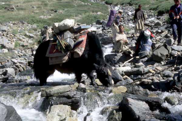
by Wakhi, coming from Tadjikistan and Persian-speaking. Wakhi
have large herds of yaks, sheep, goats as well as horses and camels.
Almost all the high valley population is Moslem of the Ismaili Shia.
The women bread and look after the herds. They very often offered me
goat's milk yoghurt, very refreshing in this arid area.
Thousand years ago the Chinese pilgrims crossing the Broghil-pass
and going to the south to search Buddhist Masters, named the
Karambar-year, "Pass of Wild Onion". Indeed there are
plenty of wild onions in the area.
This area was opened for trekking in 1992.
The trip: Seven days were necessary to go up the Yarkhun valley
and to reach the Karambar-an pass. The trail follows the right bank and
goes up gradually to north along the Afghan border, from mountain pasture
to mountain pasture. Two police checkpoints were crossed
before the Broghil-pass.
As far as Lasht, where the valley curves to east, the
landscapes are green and the plain is cultivated. The trail is
steep-side and bordered with trees. Then the landscapes got more arid, dry
and the heat was more intense. |
|
 |
|
Yarkhun river |
 |
|
a yak |
 |
|
a goat's milk yoghurt |
|
|
|
|
|
|
The Karambar-an climb, 4,343 m, allows the
crossing of the Yakhung valley to the Karambar valley. It is not a
difficult pass. The climb was pleasant with mountain pastures where I
could see the milking of goats.
|
|
|
|
|
The Karambar
valley |
|
|
|
 |
|
a yak |
 |
|
Chattiboi |
 |
|
Karambar river |
|
|
Karambar:
The Karambar river takes its source with the foot of the Eastern
face of the Karambar pass with water from the turquoise colour
lakes. The lakes are a pleasant stage for many migratory birds.
The river runs from west to bend to south at Chillinj and to be finally
a tributary of the Ishkoman river at Imit. It is the watershed between
Hindukush in the west and Karakoram in the east.
The valley is inhabited by Gujar also Persian-speaking and
ismaili. This area is known under the name of Gojal. They are
stockbreeders, like the Wakhi, in pastures well irrigated by water of the
glaciers and the lakes. The herds of yaks are many.
This trek part is the continuation of the Chinese
pilgrims road coming from Kashgar towards Gilgit, two very
important stages of the old caravan trails.
The Pakistani government has offered the Chinese government to build
a motor-road on this way, as an alternative of the Karakoram Highway.
The trip, Five days
were necessary to go down the Karambar valley and to go up the Chillinji-an
pass. The trail is on the left of the Wakhan corridor and on the right
of the Chattiboi and Chillinj glaciers, on right bank then on left bank of
the Karambar river. The change of bank was made by a metal box suspended from
a steel cable little before arriving at Chillinj. The trail continues in the
mountain pastures to reach the Western base camp of the Chillinj-an
by crossing the Chillinj glacier several times. |
|
|
|
|
|
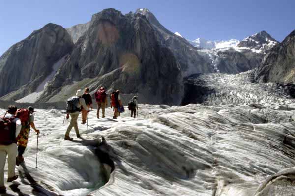
The Chillinj-an climb, 5,291 m high, allows the crossing from
the Karambar valley to the Chapursan valley. The western face is steep
and dry, the eastern face is frozen. The pass was rather painful to go up.
Suitable equipment is recommended to cross this pas. The scenery from
the snow-covered top was splendid, weather was clear.
|
|
|
|
|
The Chapursan valley |
|
|
|
|
Chapursan:
The Chapursan river takes its source at the foot of the eastern face
of the Chillinj pass. The river runs from west to east parallel to
the Chinese border. The valley consists of alluvial grounds that give
abundant food crops. The potato was recently introduced and gives the
Wakhi sufficient resources. The name of Chapursan may come from the
old man Persian, chi pursan, and may mean, Which is needed ?.
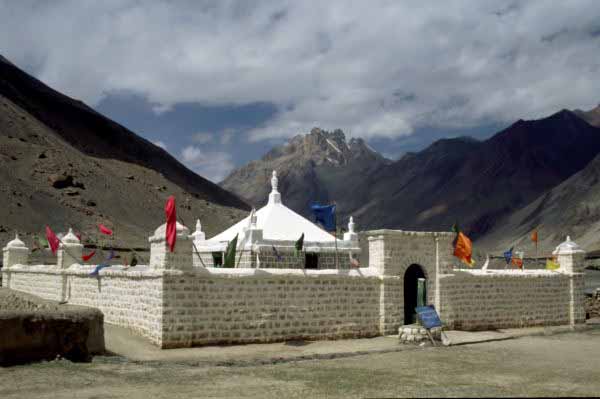
Upstream the Yaskuk glacier there is one of the most sacred sites of
this area, Baba Ghundi Ziarat. It celebrates a saint man, Moslem ismaili,
which may have made various miracles. Baba is a Hindi word which
means "Old Man" and is used with the respect due to
old people. The Chapursan dramatic scenery of small fields amid red
and yellow cliffs topped by snow peaks is strikingly beautiful.
The trip, Three
days were necessary to go down the valley from Chapursan and to go up
the village of Sost after a trip in jeep from Baba Ghundi Ziarat. |
|
 |
|
Chapursan river |
 |
|
Baba Ghundi Ziarat |
|
|
|
|
|
|
The three trek parts showed areas with different landscapes
and populations having inherited different cultures. The austere
rigorous Sunnite in the west, in Chitral, is transformed gradually into
a Sunnite adapted to the precariousness of the mountain pasture life and
becoming a septimain Shia, ismaili, in the Karambar and
especially of Chapursan valley.
This religious contrast also exists along Karakoram Highway, for
example, the Hunza valley in Karimabad is septimain Shia whereas
on the other side of the KKH the Nagar valley is dodecimain Shia.
This difference was perceived in the behaviour of the population, we
were thrown stones when we visited the Nagar valley.
|
|
|
|
|
Karakoram Highway |
|
|
|
 |
|
The KKH to north |
 |
|
The KKH to south |
 |
|
The KKH |
|
|
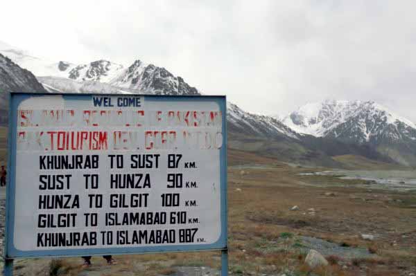
Sost, 2,750 m
high, is the last city before the Chinese border, the Xinjiang area. It
has become the customs and police station on the Pakistani side. It is a
stop for modern caravaneers, truck-drivers with their multi-coloured vehicles.
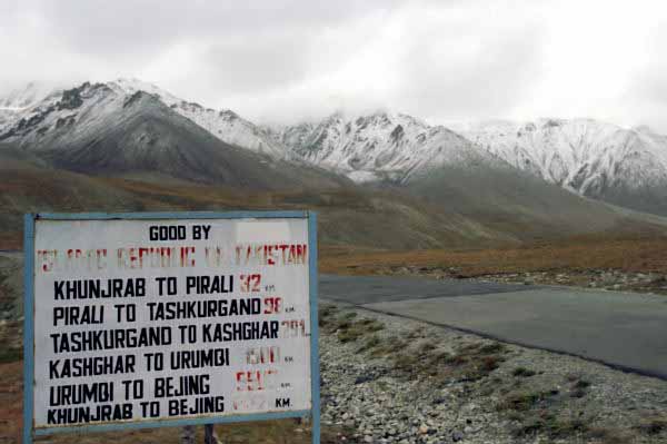
Kunjerab-pass,
4,700 m high. The collar has been opened to tourism since 1986. It is located
90 km north of Sost. Due to the snow conditions,
the pass is opened to the traffic from May to November. At the
junction of the Khunjerab and Ghujerab valleys, the Khunjerab
National Park was created in 1973 at the Dih village.
The pass is an important splitting line between two geographical, political,
ethnic and linguistic worlds. It is the passage from the attractive Hunza valley
to the austere Xinjiang and Chinese Central Asia. A notice board of the pass
warns divers, in English and in Chinese, "China : keep right - Pakistan :
keep left".
Karimabad,
2,400 m high, is a pleasant holiday resort appreciated by tourists as
well as Pakistani. The valley looks like a small Switzerland. Built
at a few kilometres away from the KKH opposite the Nagar valley, it offers an
exceptional scenery on Rakaposhi, 7,790 m high. The inhabitants,
Hunzakut, speak Burushaski which does not belong to any
known linguistic group. At the hilltop over the village dominating the
valley, the Baltit fort was the Mir residence, lord of the area. Each family
cultivates wheat, corn, apricots and nuts. Hunzacut are famous for
their longevity. I tasted Hunzawater, apricot alcohol.
Islamabad: The
return was a problem. The KKH was cut in four places by
masses of fallen rocks to torrential rain. The group remained stuck
two days in Karimabad waiting for the road to be re-opened by the
authorities. At the place of the fallen rocks they set up local
porters and tractors norias to cross and to go to the
following rock fall. After the ultimate rock fall, the return
to Islamabad was made by night to take the plane to Paris, in time. |
|
|
|
|
|
The journey in the three valleys was a discovery, it was my first
journey to Pakistan. After India and Nepal, the difference in
culture is considerable, the impacts on mentalities are important. I
made two other treks in the NWFP.
It should, however, be noticed that the three other provinces have
different and also very marked personalities.
|
|
|
|
|
The return to France was made by a PIA flight with a departure in
the morning and arrival in Paris in the afternoon.
|
|
|
|
| Neuilly, le 2003/09/06 |
|
|
|
|
|
|