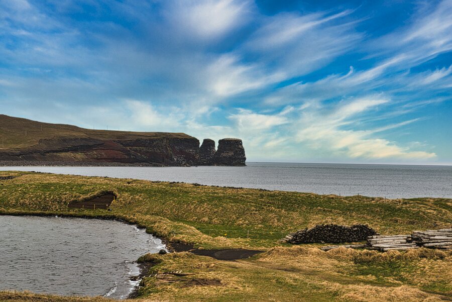
Katastadir
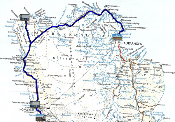
Monday June 7 I followed route 870 off the beaten track and the
horde of tourists. The landscapes are very harsh, arid without
trees, a desolation; only the sheep subsist by grazing on short
grass. From place to place, sometimes artificial ponds by the
construction of a dike for the track. I was going to Raudinupur the
most westerly point (N 66° 30.420' W 16° 30.134') of Europe
excluding the Azores. Light rain fell intermittently. I stopped at
the Kopasker grocery store and then a few kilometers further on in a
parking lot called Katastadir with interpretive signs.
click on the pic for opening the gallery
 |
| Raudinupur |
|
|
| Off the beaten track to Raudinupur |
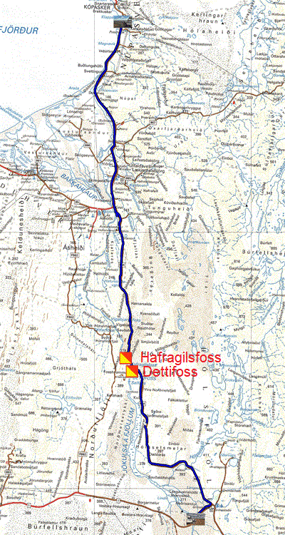
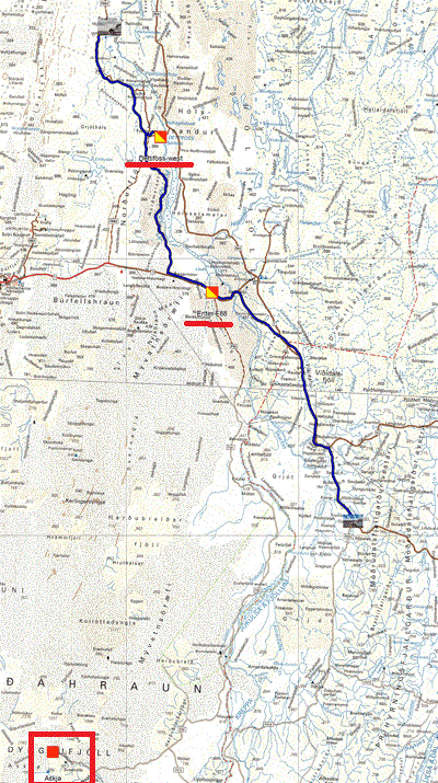
The GPS road tacklog,
Clic on the pic for openning it
from Katastadir to Junction
from 2020/06/08 to 2020/06/08
Junction_864_/_R1" Junction 864 / R1
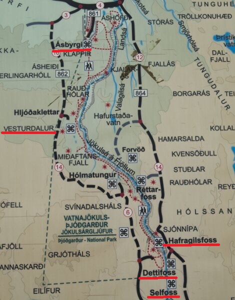
Tuesday June 8 I left early in the morning, so to speak, the night,
complete darkness is short. I arrived at an entrance gate in the
park on Route 864 at around 7:27 am. After reading the information
displayed, it took me over two minutes to understand the mechanism
for opening the said barrier! The weather was frankly gloomy, no
light and no color, everything is bland without contrast. The first
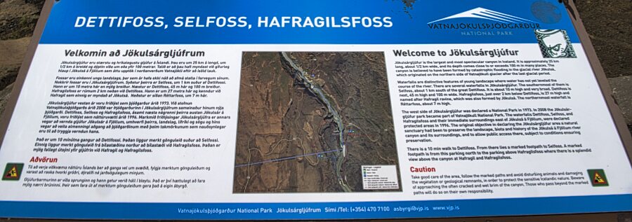
waterfall, Hafragilsfoss, is easily accessible. However Dettifoss
requires a 10 minute walk, according to the information panel, over
rocks with steep stairs. It took me almost 20 minutes to get near
Dettifoss. Certainly, they are impressive, but far from African
Falls or Niagara. Dettifoss' return to the parking lot was a piece
of bravery. Route 864 is an advertised 4x4 track; but it is
practicable, during my passage by 2x2. I bivouacked near the
interpretive panels of the R1 road not far from the junction with
the 864.
click on the pic for opening the gallery
 |
| Waterfalls |
|
|
| Enter route F864 towards Dettifoss, story without words. "I am not Buster Keaton" |
.
The GPS road tacklog,
Clic on the pic for openning it
from Junction to Vesturdalur
from 2020/06/09 to 2020/06/09
Vesturdalur
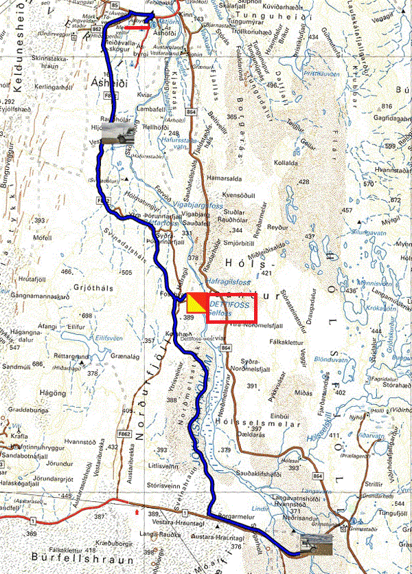
Wednesday June 9 was a day of desolation, rain & fog, during the visit
of Dettifoss-west and Selfoss from road 862 (asphalted). In addition,
the Vesturdalur site is not accessible under works. No longer having any
appetite for hiking in the rain, I abstained. I continued on my way to
Asbyrgi to refuel fuel and food. The local supermarket is poor and
expensive, for tourists. I filled the tanks and five-liter cans with
water for drinking at the deserted campground. Then I sat down to the
Information Center with my two laptops to install the Windows 10
Wednesday monthly update as well as the large Buster Keaton video post,
No One Is Perfect. I returned to the Vesturdalur parking lot to bivouac.
As a reminder, the videos are made continuously by the Dash Camera
sucked into the windshield.
click on the pic for opening the gallery
The GPS road tacklog,
Clic on the pic for openning it
from Vesturdalur to Enter F905
from 2020/06/10 to 2020/06/10
Enter F905
Thursday June 10 the morning began with a ray of sunshine. I was
rushing back to Dettifoss-west. I had time to take a few pictures
before a grain fell. I took the opportunity to do maintenance,
indeed the direction change indicators and the horn were no longer
working. I was looking for the fuse in question, one by one, because
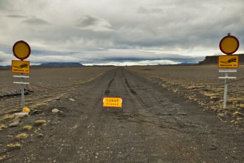
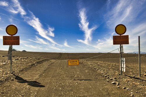
the instructions are in Tudesque language! I decided to try my luck
to go to Askja caldera knowing that the tourist information had told
me that the F88 road was closed; well yes, it was. But I am
stubborn. I was going to see if the F905 and F910 roads were open;
well no, they were closed. I bivouacked there. I said I'm skipping
school. The afternoon was cold but sunny.
click on one pic for opening the gallery
 |
 |
| Enter F88 |
Enter F905 |
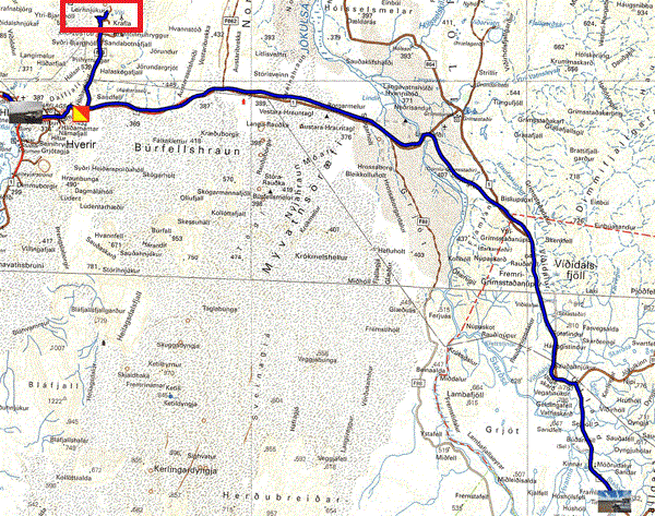
The GPS road tacklog,
Clic on the pic for openning it
from Enter F905 to Reykjahlid
from 2020/06/11 to 2020/06/11
Reykjahlid
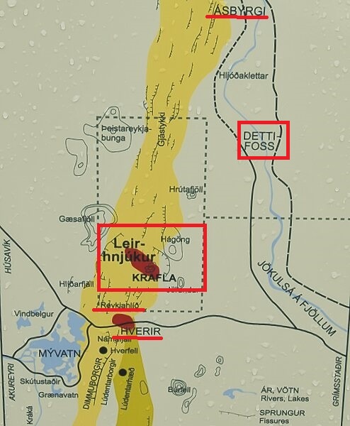
Friday June 11th I opened an eye to the all white surroundings. The
outside temperature was 0°C at an altitude of 490 meters above the
sea. Again I sank into my sleeping bag. The day was looking gloomy
with overcast skies and an average temperature of 4°C. The visits
were not frivolous. On the way I passed near the "geothermal power
station"; this is the occasion to say that Iceland is 100%
renewable. The access to the Viti-Krafla crater was muddy, slippery
and steep; I stopped halfway down the hill. The show was not there,
the crater lake was whitish and not the deep blue as advertised.
Shortly before, but visited after, Leirhnjukur is supposedly
facilitated by a board walk, but it is partially smashed requiring
to wade through the mud. Before arriving in Reykjahlid I ended with
Hverir with its sulphurous mud and fumaroles. The spectacle would
have to be splendid as geothermal energy is omnipresent in a very
colorful landscape. Alas, alas, alas everything was dull, bland
unattractive. My route plan took into account the trip to Greenland
canceled at the beginning of June by Hurtigruten. At the risk of
being confronted with the horde of tourists, the advice is to travel
from mid-July to mid-August. In Reykjahlid I went shopping at the
local supermarket. As already said the prices are soaring, a 500
gram jar of skyr, Icelandic yogurt, is sold 450kr in Egilsstadir and
here 629 kr, where is the error! Only the price of diesel is the
same (229.90 kr per liter, around 1.558 € per liter), regulated
price.
click on one pic for opening the gallery
The GPS road tacklog,
Clic on the pic for openning it
dfrom Reykjahlid to Reykjahlid
from 2020/06/12 to 2020/06/12
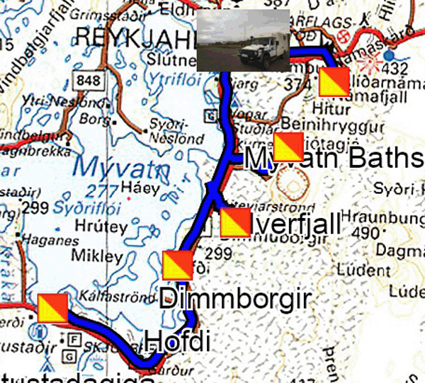
Myvatn-1
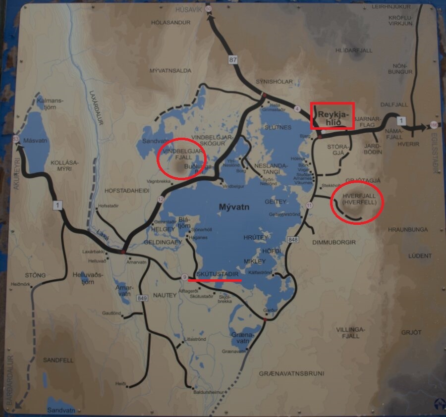
Saturday June 12 I woke up with a completely white environment. The
outside temperature was -0.5 ° C. I set out to explore the lava
sites sculpted by the entropic erosion of time. In the order of the
photos in the gallery below it was Dimmuborgir, the most
spectacular, of which I rode the yellow & red circuit. Then Höfdi
offers sculptures immersed in blue water. Skutustadagigar presents
pseudo craters which I only visited closest to the shore. Finally
the last photo is that of Hverfjall appeared 2700 years ago. It is
possible to hike to the top of the crater after a steep climb of
about 20 minutes to an altitude of 452 meters; I abstained. I
finished the day after administrative work by taking a bath at
Myvatn Nature Baths.
click on one pic for opening the gallery
The GPS road tacklog,
Clic on the pic for openning it
from Reykjahlid to Reykjahlid
from 2020/06/13 to 2020/06/13
Mytavn-2
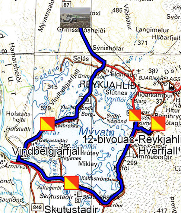
Sunday June 13 was another day of snow. I was going to Hverfjall to
see, if the climb was possible, of course it was not with visibility
of a few meters. In Skutustadagigar I took the photo from the
previous day, under the snow. Finally I took a picture of the
mountain Vindbelgjarfjall, obviously under the snow. I continued to
a parking lot called parking lot in a field where bags were stored.
It was still snowing and the temperature was -1.5 ° C. The wind was
strong pushing gusts of snow. Around Myvatn Lake all possible
parking places have a no overnight bivouac sign.
click on one pic for opening the gallery