La Mauritanie est le pays des Maures. Pour plus ample information sur ce pays consultez le site Wikipédia :
![]() Mauritania is the land of the Moors. For further information about this country consult the Wikipedia site:
Mauritania is the land of the Moors. For further information about this country consult the Wikipedia site:
![]()
Le dossier PDF du voyage a été conçu avec le logiciel de navigation QuoVadis
![]() à partir des deux livres, Mauritanie au GPS de Sylvie
& Cyril et Pistes de Mauritanie de J. Gandini ainsi que des voyages de
Jacomo et d’Agirard trouvés sur Internet. Bien sûr c’est un projet, la
réalité est une autre histoire, à suivre ! Contrairement au titre des pages
du dossier il s’agit d’un road plan non d’un road book qui ne peut être
réalisé qu’a posteriori ; je ne le ferai pas, c’est un job.
à partir des deux livres, Mauritanie au GPS de Sylvie
& Cyril et Pistes de Mauritanie de J. Gandini ainsi que des voyages de
Jacomo et d’Agirard trouvés sur Internet. Bien sûr c’est un projet, la
réalité est une autre histoire, à suivre ! Contrairement au titre des pages
du dossier il s’agit d’un road plan non d’un road book qui ne peut être
réalisé qu’a posteriori ; je ne le ferai pas, c’est un job.
The PDF trip file was designed with the QuoVadis navigation software
![]() from the two books, Sylvie & Cyri’s Mauritanie au GPS and J. Gandini's
Pistes de Mauritanie, as well as Jacomo and Agirard's trips found on
Internet. Of course it's a project, the reality is another story, to follow!
Contrary to the title of the pages of this file it is about a road plan not
a road book which can be realized only posteriori; I will not do it, it's
a job.
from the two books, Sylvie & Cyri’s Mauritanie au GPS and J. Gandini's
Pistes de Mauritanie, as well as Jacomo and Agirard's trips found on
Internet. Of course it's a project, the reality is another story, to follow!
Contrary to the title of the pages of this file it is about a road plan not
a road book which can be realized only posteriori; I will not do it, it's
a job.
Le dossier du voyage au format pdf, the PDF trip file est / is
![]() .
Le tableau de synthèse, the summary table est / is
.
Le tableau de synthèse, the summary table est / is
![]() .
.
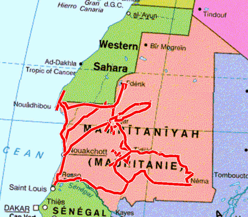
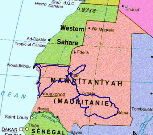
La carte ci-dessous montre le tracé prévisonnel du voyage qui sera actualisé in fine. The map below show the expected track of the journey which will be updated in fine.
| Expected roadplan | Realized tracklogs |
 |
 |