-- From Las Vegas to Bryce Canyon
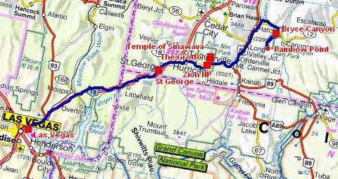
The road tracklog
from Las Vegas to Bryce Canyon
from 2011/03/14 to 2011/03/20
The day of Monday in Las Vegas was studious to prepare the trip in the National Parks and to schedule the change of the tires at Salt Lake City, capital of Utah, before leaving the USA imperatively on May 04 at the latest, the advice of the customs officer at the border in Vancouver.
The following day the departure from Las Vegas was not with brass band. The sky was cloudy and the rectilinear Hwy 15 in the desert was endless. To reach Utah, State of the Mormons, I surreptitiously crossed Arizona and the sumptuous Virgin River Gorge before arriving in St George whose nickname is “Dixie”. After a stop at Walmart to make supply, the carpark was prohibited for RV, and the diesel filling at the Pilot Travel Centers, I bivouacked there between two huge noisy trucks.
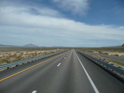
Endless road
Hwy 15
15/03/2011

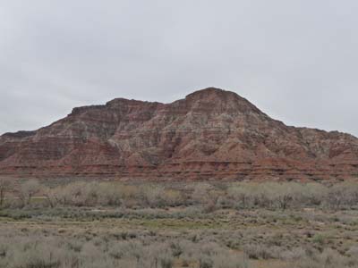
Virgin River Gorge
Hwy 15
157/03/2011
USA's National Parks
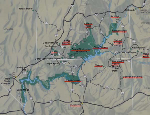
This map shows the main parks of my trip: Zion, Bryce Canyon, Capital Reef, Natural Bridges, Valley Monument, Grand Canyon, Canyon de Chelly, Mesa Verde, Canyonlands and Arches.
Zion National Park
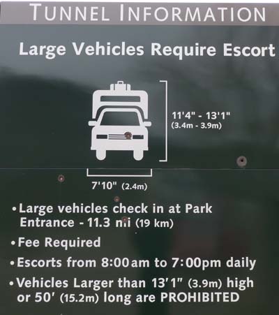
At the Zion Park entrance a sign post gives the conditions of crossing of a tunnel to leave it by the Hwy 9 eastwards to Bryce Canyon. I paid a fee at $15 due to the size of my truck.
Sign Post
Park entrance
16/03/2011
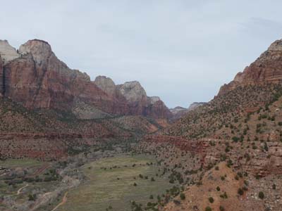
Landscape
Hwy 9
15/03/2011

Landscape
Hwy 9
16/03/2011
At the Visitor Center I was informed that the Watchman campground was full and that I was to go to South campground. After lunching I undertook a digestive walk and for setting in leg by strolling the Watchman Trail. Back I got informed about the weather conditions to try the Angels Landing Trail whose track would be covered by snow, to follow. Indeed the weather was overcast and gloomy tarnishing the red and ocher color of the surrounding mountains whose tops were capped by snow.

Watchman trail
Hwy 9
16/03/2011

Landscape
on Watchman trail
16/03/2011
Landscape
on Watchman trail
16/03/2011
However in the evening the sunset made its appearance illuminant magnificently the mountains over the South campground.

Landscape
from South campground
16/03/2011
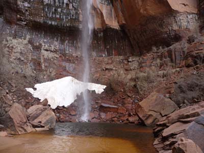
From early morning I traversed the Scenic Drive to go to Temple of Sinawava terminus of the road before The Narrows. Alas only the Riverside Trail was opened, The Narrows were closed until mid-April, i.e. impossible to wade in cold water what we had done in August 1991.
Landscape
on scenic drive
17/03/2011

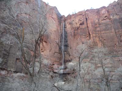
The Narrows
17/03/2011
Back to The Grotto I parked my truck to make the climb of Angels Landing at 1765 meters high, about 472 m of uneven. The final phase of the last 800 meters is equipped with chains fixed at rock. The view in spite of a covered weather is dramatic on the gorge cut by the Virgin River for million years.

Angels Landing Trail
17/03/2011

Angels Landing Trail
Tracklog
17/03/2011

Angels Landing Trail
17/03/2011
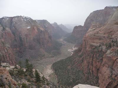
Virgin River Gorge
Angels Landing
17/03/2011
The night was very windy consequently it was spangled. In the early morning I decided to remain one more day to walk Zion NP by good weather. On Scenic Drive I surprised stags crossing the roadway in front of my truck. I have only time to slow down and take a picture of the reducing animals in the forest. By arriving at The Grotto I decided to put a coat again by climbing one second time Angels Landing by hoping that the sun lights Virgin River Gorge. During the climb the wind was always violent and cold. At the top the sun did not illuminate the gorge, I waited until 11:30. By having patience I observed fauna many squirrels particularly nimble and difficult to photograph.
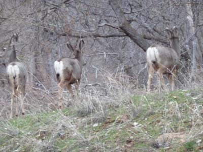
Deers
on Scenic Drive
18/03/2011

Angels Landing
Zion NP
18/03/2011
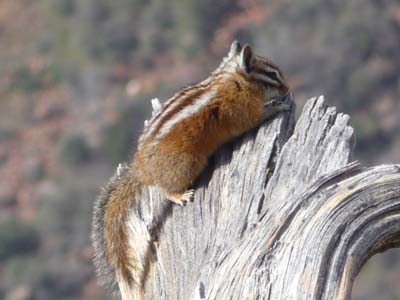
Squirrel
Angels Landing
18/03/2011

Virgin River Gorge
Zion NP
18/03/2011
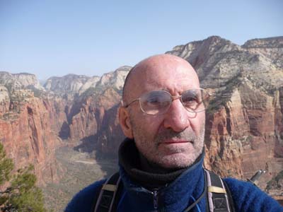
Auto portrait
Angels Landing
18/03/2011
At the return I prolonged the trekking by visiting the Lower and Upper Emerald Pool. In this season a light fog veiled the sun tarnishing the colors of the landscape. I had walk a little more than 18km.
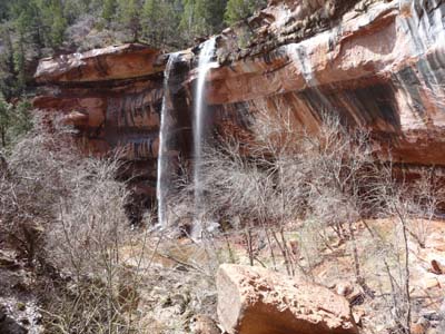
Lower Emerald Pool
Zion NP
18/03/2011
Upper Emerald Pool
Zion NP
18/03/2011
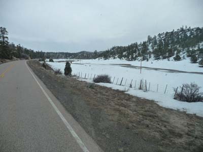
On Saturdays March 19 at 8 a.m. I was at the entry of the Tunnel in Zion NP to be escorted, actually a ranger informed his colleague at the other end, 1.1 miles further away, that a truck except gauge entered the tunnel. Indeed at the exit some cars were on standby. On Hwy 89 snow made its appearance on the Paunsaugunt Plateau at around 2100 meters high.
Paunsaugunt Plateau
Hwy 89
19/03/2011
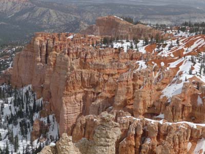
Bryce Canyon National Park
At the crossroads of Hwy 63 towards Bryce Canyon, there were not many tourists in spite of the weekend, moreover only one campground was partially open. I went up to Rainbow Point by the Scenic Drive, approximately 25 km. Then back towards the entry of the park I visited the various lookouts. With happiness a sunbeam appeared surreptitiously around 12 noon to light the landscape during approximately half an hour. The spectacle under snow was imposing emphasizing the pink color. Actually it is not a canyon but a cliff eroded by time and weathering.


South Point
Bryce Canyon NP
19/03/2011

Yovimpa Point
Bryce Canyon NP
19/03/2011
Rainbow Point
Bryce Canyon NP
19/03/2011

Agua Canyon
Bryce Canyon NP
19/03/2011
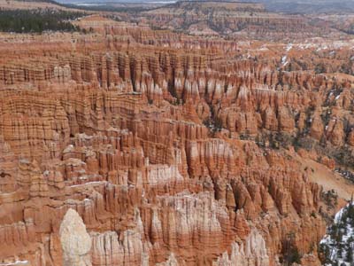
Natural Bridges are formed by wind and acid rains then are reduced to columns after thousands of years. The altitude of the park lies between 2400 and 2800 meters high with at present a thickness of snow from 20 to 40cm.

Natural Bridget
Bryce Canyon NP
19/03/2011
Bryce Point
Bryce Canyon NP
19/03/2011

Bryce Point
Bryce Canyon NP
19/03/2011
A Visitor Center offers a WiFi Internet connection, I benefited from it to launch some emails because my Webasto X100 diesel cooker does not function any more after five years of good and faithful services. According to the user manual the Glow Plug would be in question. I found a bivouac in the North Campground.
As of early dawn I was At Sunrise Point to admire the sunrise on the Bryce Amphitheater. Alas it did not scorn to appear.

Sunrise Point, 7:30am
Bryce Canyon NP
20/03/2011
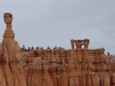
I came back around 11 a.m. to this starting point of a trekking combining Queens Garden and Navajo Loop. Of course the sun was not there, moreover the track was muddy making my pants of pink color. This walk of more than five kilometers in one hour and forty minutes offered an unforgettable view from the Hoodoos' inside. I regretted the absence of sun for my pictures. About midday scattered snowflakes came to decorate this cold walk.

Trekking
Bryce Canyon NP
20/03/2011
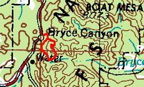
GPS Tracklog
Bryce Canyon NP
20/03/2011

Queens Garden
Bryce Canyon NP
20/03/2011

Navajo Lop Trail
Bryce Canyon NP
20/03/2011
Navajo Loop, Windows
Bryce Canyon NP
20/03/2011
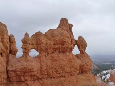
Navajo Loop, Windows
Bryce Canyon NP
20/03/2011