-- From Bryce Canyon to Halls Crossing

The road tracklog
from Bryce Canyon to Halls Crossing
from 2011/03/21 to 2011/03/27
USA's National Parks
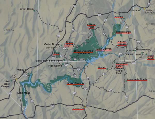
This map shows the main parks of my trip: Grand Staircase, Capital
Reef, Natural Bridges, Valley Monument, Grand Canyon, Canyon de Chelly, Mesa
Verde, Canyonlands and Arches.
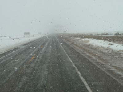
Monday March 21 before leaving Bryce Canyon I made a long stop at the Visitor Center to use an Internet WiFi connection. I hold a Skype meeting with my brother, back bases in Draguignan, to look for a Glow Plug for the Webasto diesel cooker X100. Then I posted some emails in USA to know the Webasto product dealers in the area of Salt Lake City, to follow. The experiment shows that I never have the spare part which I need. On the move gusts of snow darkened the visibility making my progression difficult.
En route
Hwy 12
21/03/2011
Grand Staircase
By heading down to Escalante in Grand Staircase the snow falls ceased, but in the Visitor Center the weekly weather forecasting was hardly encouraging.

Hazardous Weather Outlook
Escalante Visitor Center
21/03/2011
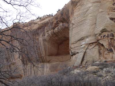
Around midday I observed a Recreational Area of the Bureau of Land Management –BLM– at the edge of a sympathetic river, I stopped there to lunch then finally to bivouac.

Trail map
Calf Creek Falls
21/03/2011
At the beginning of the afternoon I undertook the suggested walk, a trip on line of 6 miles on a not very broken sandy ground. But by putting my walking shoes I have the unpleasant surprise to discover that the Vibram soles were separated. They were bought “Au Vieux" in Paris before leaving France, there are Meindl made in…, the name is enough to know the nationality of the manufacturer.

Guy's walking shoes
Calf Creek Falls
21/03/2011
During my progression the weather was dubious, but without rain. The cliffs were of various colors according to the chemical composition of the rock. The water falls at the terminus of the walk were splendid. I went back to the campground by limping with my patched up shoes.
Landscape, cliff
Calf Creek Falls
21/03/2011

Lower Calf Creek Falls
Calf Creek Falls
21/03/2011
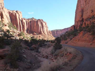
At Boulder I left the Hwy 12 to drove the Burr Trail Road towards Capitol Reef NP. The highlight of the day was the crossing of the Long Canyon worthy of a ambush according to the good tradition of the Spaghetti Westerns. Colors were extraordinary under the sporadic rays of the sun.

Long Canyon
Burr Trail Road
22/03/2011
Long Canyon
Burr Trail Road
22/03/2011

Long Canyon
Burr Trail Road
22/03/2011

En route
Burr Trail Road
22/03/2011

En route
Burr Trail Road
22/03/2011
At the exit of the canyon the view on cliffs of Capitol Reef NP was an enchantment with at the back the snow-capped mountains under clouds heralding falls of snow. I lunched on a picnic area at Burr Trail Switchbacks before returning towards Boulder.

En route
Burr Trail Road
22/03/2011

Capitol Reef
Burr Trail Road
22/03/2011
Capitol Reef
During the night the temperature had fallen to - 5°C, the roof of my truck was covered by white frost crystals. I waited until the sun heats the atmosphere to leave around 10 a.m. The road towards Capitol Reef, Hwy 24, climbed up to 2880 meters, the roadway was icy. Then it went down brutally to 1660 meters GPS towards Fruita where local sights are, Visitor Center and the campground. Along the Hwy many tracks to lookout were closed because of snow. The tourist season begins end of April.

2880m
Hwy 24
23/03/2011

Icy road
Hwy 24
23/03/2011
Capitol Reef
Hwy 24
23/03/2011

Landscape
Hwy 24
23/03/2011

The Castle
Hwy 24
23/03/2011
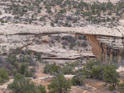
In the early afternoon I went for a small walk of two miles round trip to see a sumptuous stone bridge, Hickman Bridge, dug by water streaming during million years.

Hickman Bridge
Hwy 24
23/03/2011
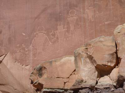
Hopi people engraved on cliff some Petroglyphs. I bivouacked at Fruita knowing that the weather forecast for the following days were in line with those from Escalante, to follow.
Petroglyphs
Hwy 24
23/03/2011

Deer?
Hwy 24
23/03/2011
Most of the next day was devoted to a long walking of more than 15 km GPS round trip in less than five hours to look at sumptuous landscapes in Capitol Reef NP and on arrival the dramatic Cassidy Arch. The weather forecasting by the Visitor Center was however not favorable. Indeed at daybreak a snow fall occurred temporarily. The progression was a true play of track from rock cairn to rock cairn, I was twice in difficulty to find it. I was alone on the trail, no alive soul, alone in the immensity with the only noise of wind and of rock cracking by temperature, a true pleasure.

Trekking to Cassidy Arch
Ranger Map
24/03/2011

GPS tracklog
Trekking Cassidy Arch
24/03/2011

Cassidy Arch
24/03/2011
The various layers of sedimentation are perfectly visible. Geological sculptures along the track teach the process of erosion according to the hardness of the rocks. The last picture shows a rock at the top of a pylon whose base is friable; in a few millennia the fall will be inevitable in a great crash, a true geological lecture in situ.

Geological Feature
Cohab Canyon
24/03/2011

Geological Feature
Frying Pan Trail
24/03/2011

Geological Feature
Frying Pan Trail
24/03/2011
Glen Canyon National Recreation Area
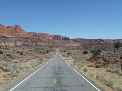
A short driving day to enter Glen Canyon NRA. Hwy 24 left Capitol Reef NP without glare. On the other hand the entry in Glen Canyon was very colored with huge geological structures carved by millionaire erosion. Deep canyons were cut by streaming water. Weather being dubious I stopped in Hite not far from Colorado River at the foot of ocher cliffs. The wind was violent.

Geological Feature
Hwy 95
25/03/2011

Dirty River
Hwy 95
25/03/2011

Geological Feature
Hwy 95
25/03/2011

Colorado River
Hwy 95
25/03/2011

Colorado River
Hwy 95
25/03/2011

Geological Feature
Hwy 95
25/03/2011
The day of Saturday March 26 was announced with a covered sky, it was it and it snowed in Natural Bridges as of 16:30 at the altitude of 1966 meters GPS. On the way on Hwy 95 information panels gave names to more or less characteristic geological structures.

Jacob's Chair
Hwy 95
26/03/2011
Cheese Box Butte
Hwy 95
26/03/2011
I made a diversion into Fry Canyon to have lunch. The landscape was majestic in spite of a little of luminosity.

Geological Feature
Fry Canyon
26/03/2011

Landscape
Fry Canyon
26/03/2011
Natural Bridges National Monument
Natural Bridges National Monument has three natural bridges dug by the torrents. Under a cliff in a large alcove ruins of a settlement of the ancestors of modern Puebloan.

Sipapu Bridge
Natural Bridges
26/03/2011

Landscape
Natural Bridges
26/03/2011

Kachina Bridge
Natural Bridges
26/03/2011
Owachomo Bridge
Natural Bridges
26/03/2011
Glen Canyon-Lake Powell
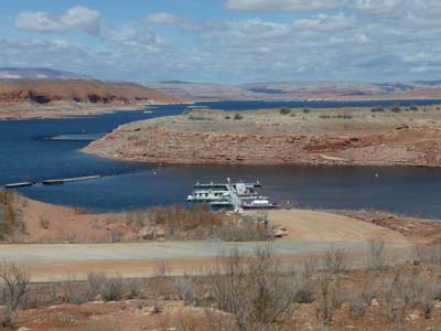
Sunday morning the roof of my truck was covered with ice, the temperature was under 0°C after the snow falls during the day before. I decided to head to Halls Crossing in the hope to find a Internet connection. On the way landscapes were always also beautiful with colors varying from red to ocher according to the incidence of the sun rays which were this morning very seldom. The sky seemed to want to be clear about midday. Halls Crossing in this season was deserted, nobody in the campground, the ferry for Bullfrog was closed and the Marina inactive. What a loneliness!

Landscape
Glen Canyon
27/03/2011
Lake Powell
Glen Canyon
27/03/2011