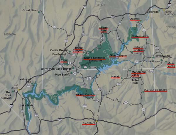
-- From Halls Crossing to Grand Canyon

The road tracklog
from Halls Crossing to Grand Canyon
from 2011/03/28 to 2011/04/03
USA's National Parks
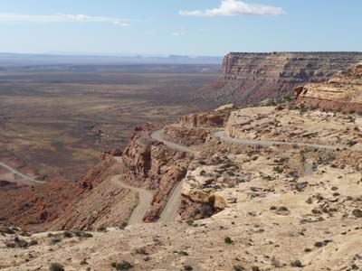
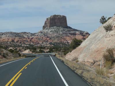
Monday March 28 I moved towards “The well-known Monument” in the whole world by Hollywood movies oin particular with John Wayne in 1938, Monument Valley. The Hwy 261 head down by a dirt road for 5 miles towards Mexican Hat which owes its name after a rock like a Mexican hat. I lunched in the vicinity.
Dirt road towards Mexican Hat
Hwy 261
28/03/2011
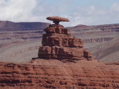
Mexican Hat Rock
Hwy 261
28/03/2011
Museum
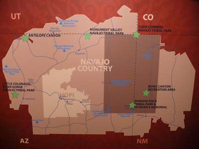
Navajo Country
28/03/2011

Museum
Navajo Population
28/03/2011
Hwy 163 offers an unforgettable approach of Monument Valley in spite of a bad luminosity. The museum inside a Visitor Center gives a short outline of the Navajo's culture as their participation at WWII. The 17-mile trip inside the park meanders between the geological sculptures, called as The Three Sisters, Totem Pole, John Ford Point etc There too in spite of a bad luminosity the sight is stunning, with imagination it is possible to hear the Hollywood cow-boy's ride. I bivouacked on a Primitive Campground. The sunset is exhibited by the Gallery.
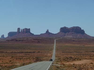
Monument Valley, Landscape
Hwy 163
28/03/2011
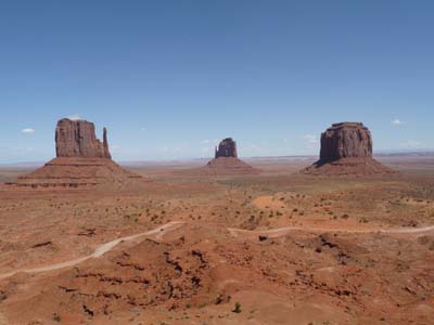
Lookout
Monument Valley
28/03/2011
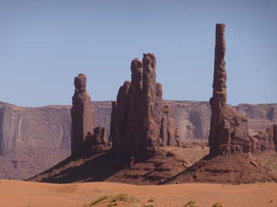
Totem Pole
Monument Valley
28/03/2011

John Wayne
Monument Valley
28/03/2011
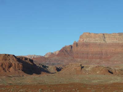
The following day I attended as from 7 a.m. the sunrise which was also impressive but difficult to take in photograph without special filters. After Monument Valley nothing appears beautiful, landscapes are without glare nor majesty. On the way towards Page at the edge of the Lake Powell, the Square Butte attracted despite everything my attention. The town of Page did not appear very attractive, along a street Churches of all allegiances followed one another in litany, Church Row.
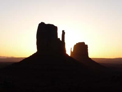
Sunrise
Monument Valley
29/03/2011
Square Butte
Hwy 98
29/03/2011
Alas on Wednesday March 30 I got up one hour too early, Arizona is one of the states not to practice the summer-time –DST, Daylight Saving Time– I was as of 7:30 am at Glen Canyon Dam to collect booklets in the Carl Hayden Visitor Center. The remainder of the morning was devoted to administrative tasks, address of the Central Post Office in Salt Lake City for receiving some spare parts in poste restante, phone call with the Michelin tires dealer in Salt Lake City, piece of bravery, but an American gentleman noting my embarrassment carried out this call for me, prolonged stop at McDonald's for email sending. In the afternoon I visited Wahweap and its marina without nautical activity, then Lone Rock. The landscapes of the Lake Powell in low water were not very attractive. At Lone Rock some campervans occupied the edge of the lake, I decided to bivouac in front of this insolated rock.
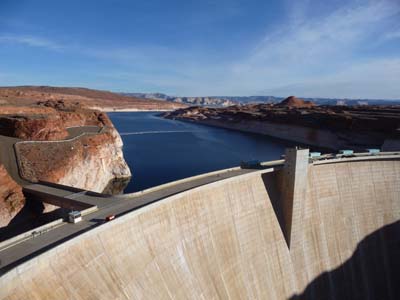
Glen Canyon Dam
Page
30/03/2011
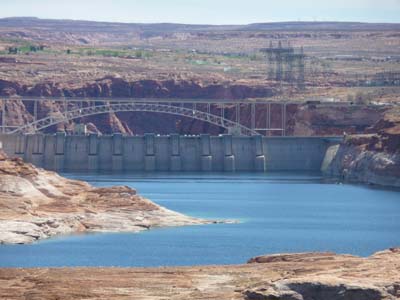
Dam & Bridge
Page
30/03/2011
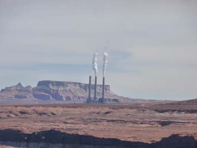
Coal power plant
Page
30/03/2011
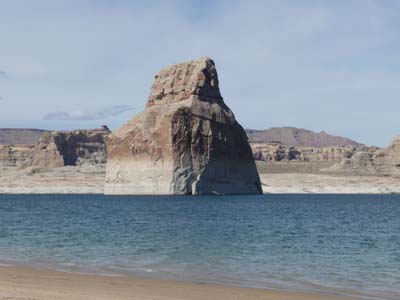
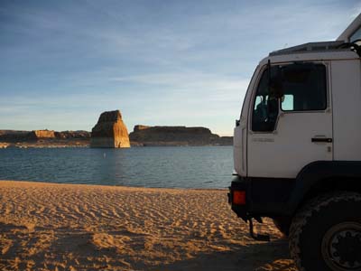
Lone Rock Beach
Page
30/03/2011
The sunrise on Lone Rock Beach was stunning.
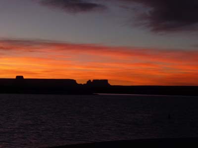
Sunrise, Lone Rock Beach
Page
31/03/2011
Sunrise,
Lone Rock Beach
Page
31/03/2011
On the move towards Lees Ferry in Glen Canyon I made several stops of which the first was at McDo to read messages in my mailbox. Then it was a lookout on Horse Bend, dramatic meander of Colorado River; in a few million years there could be a Natural Bridge. At the crossroads between Hwy 89A and a road to Lees Ferry the Navajo Bridge offers a view over the Colorado River.
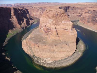
Horse Bend
Hwy 89
31/03/2011
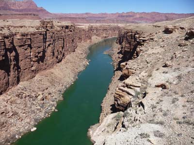
Navajo Bridge, Colorado River
Hwy 89A
31/03/2011
Finally I wished to see Cathedral Wash a walk of -3 mile round trip- announced as moderate. Alas my progression was stopped by a descent in the canyon which proved to be impossible for me without endangering my physical integrity. I gave up the death in my heart close to the target -a wise man knows his limits- Clint Eastwood.
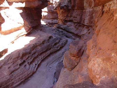
Lower Cathedral Trail
Road to Lees Ferry
31/03/2011
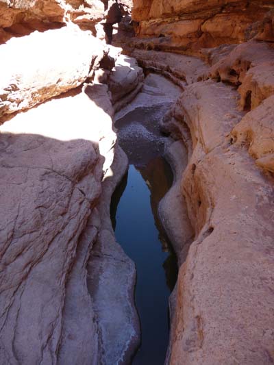
Lower Cathedral Trail
Road to Lees Ferry
31/03/2011

Balanced Rock
Road to Lees Ferry
31/03/2011
At the end of the road an huge truck unloaded boats for Colorado River's descent in raft. I bivouacked on the spot.
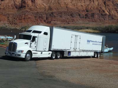
Boat Ramp
Road to Lees Ferry
31/03/2011
At the departure from Lees Ferry the sunrise emphasized the colors of the Vermillon Cliffs. The Hwy 89 up to Cameron then the 64 up to Little Colorado River are not of any interest.
Sunrise
Lees Ferry
01/04/2011
The first stop was thus at the gorges of Little Colorado River in Navajo territory. The river takes its source at Mt Baldy before joining Colorado River in the Grand Canyon. Their narrowness marks a great difference with the width of the Grand Canyon.
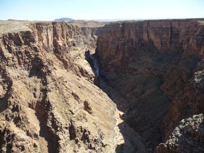
Little Colorado River
Hwy 64
01/04/2011
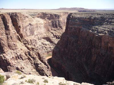
Little Colorado River
Hwy 64
01/04/2011
Grand Canyon National Park
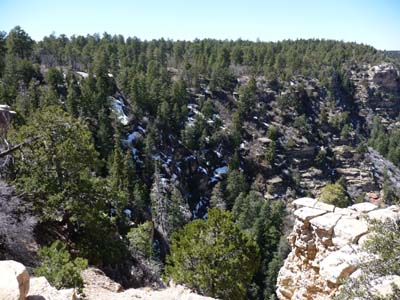
After the entry in Grand Canyon National Park several stops on Desert View Drive offer some lookouts; most remarkable were Desert View and Grand View Point. The luminosity at the beginning of afternoon was not favorable for pictures. Some snow plates were still visible on the wooded slopes exposed northwards. In Tusayan I lunched at McDo for surfering on Internet.
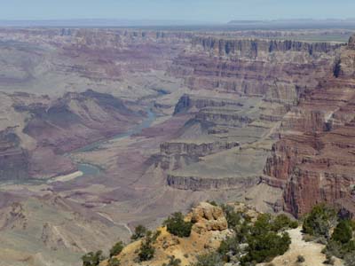
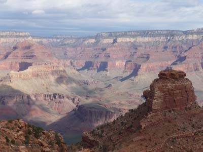
Desert View
Desert View Drive
01/04/2011
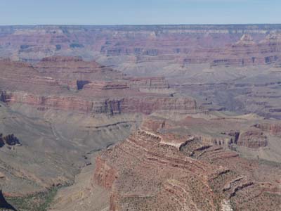
Grand View Point
Desert View Drive
01/04/2011
Grand View Point
Desert View Drive
01/04/2011
After having established my camping in Mather Campground for three nights I took two free shuttles to go to Hopi Point to attend sunset, always magic moment. I must say that the organization of the park moved since my first visit, it is in all remarkable points.
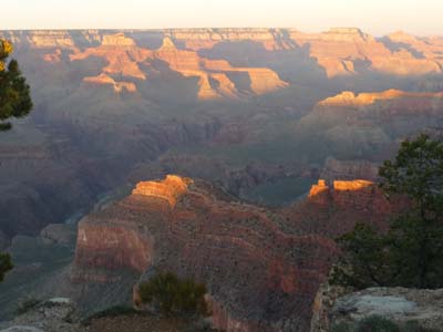
Sunset
Hopi Point
01/04/2011

Sunset
Hopi Point
01/04/2011
Of course I should go down in the Grand Canyon. Saturdays morning I undertook the Bright Angel walk up to Indian Garden given for 4.6 miles i.e 7.4km one-way. The GPS posted at the back 17.3km that I walked in 1:55 to the outward journey and 2:20 to the return. The uneven was approximately 1200 meters. The landscapes is gigantic, it is giant. Nature made in disproportion…
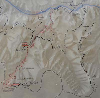
Bright Angel Trail
Grand Canyon
02/04/2011
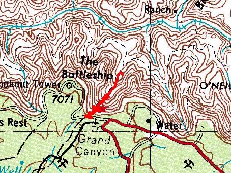
Trace GPS
Grand Canyon
02/04/2011
Bright Angel Trail
Grand Canyon
02/04/2011
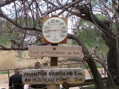
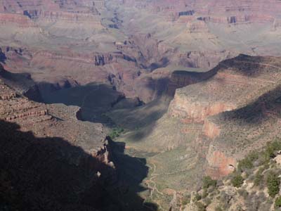
Indian Garden
Grand Canyon
02/04/2011
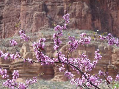
Indian Garden
Grand Canyon
02/04/2011
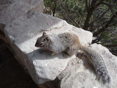
Ground squirrel
Grand Canyon
02/04/2011
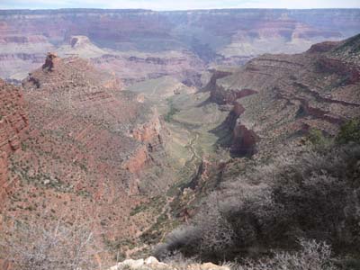
The next day I went down again in the Grand Canyon with a target to reach the Colorado River by South Kaibab Trail -in red- then by going along it up to Pine Creek and back by Bright Angel Trail -in black- with a new passage at Indian Garden. It was a trekking of 6:30 to walk 26.7 km by leaving at the altitude of 2178m to arrive at the bank of Colorado River at 720m and to go up to the village at 2055m, given GPS. Landscapes were always also imposing with a more favorable lighting. I returned exhausted but happy.
South Kaibab Trail-Bright Angel Trail
Grand Canyon
03/04/2011
Trace GPS
Grand Canyon
03/04/2011

South Kaibab Trail
Grand Canyon
03/04/2011
South Kaibab Trail
Grand Canyon
03/04/2011
South Kaibab Trail
Grand Canyon
03/04/2011
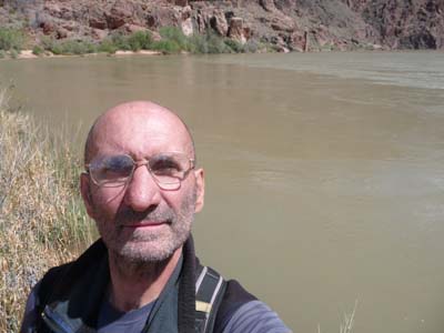
Auto portrait-Colorado River
Grand Canyon
03/04/2011
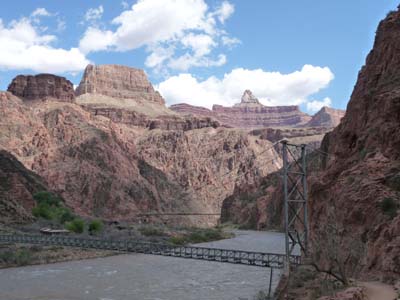
Silver Bridge & Black Bridge
Grand Canyon
03/04/2011
Bright Angel Trail
Grand Canyon
03/04/2011